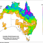
Active Monsoon Soaks Queensland
02/12/2025, 12:06 pm EST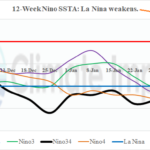
Madden Julian Oscillation Triggers High Impact U.S. Weather Events; Weakens La Nina
02/18/2025, 8:15 am EST
Highlight: Next week’s forecast trend is colder. Gulf States impacted. Frigid Central into East. HDD count is 58 colder than normal for next week (Jan. 19-25 was 59 colder than normal).
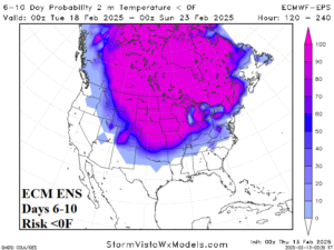
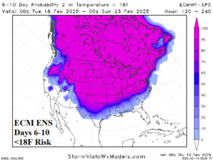
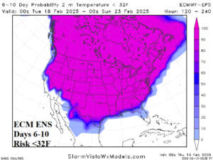
Fig. 1-3: The ECM ENS risk of <0F, <18F, and <32F regions for the 6-10-day period (TUE-SAT next week).
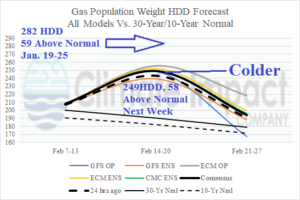
Fig. 4: U.S. gas population weight HDD forecast using all models, their consensus, comparing with yesterday and the 30-year/10-year normal.
Discussion: All models agree, next week’s forecast which is already frigid trends colder. ECM is the coldest model. The cold weather thresholds are edging farther southward next week. The risk of <0F touches the Kansas/Oklahoma border (Fig. 1). Previous forecasts had the risk of <0F to the northern Kansas border. The farther south shift is inspired by new snow cover. Proximity of snow cover to Texas supports a colder risk to ERCOT. The risk of <18F is just south of Dallas and extends east to Birmingham to Raleigh (Fig. 2). The risk of <32F reaches the northwest Gulf of Mexico Coast and the Carolina Coast (Fig. 3). The U.S. gas population weight HDD forecast for next week increases to 249 HDD which is 58 colder than normal (Fig. 4). The January 19-25 HDD count was much colder, 282 HDD but similarly colder than normal. Snowfall events help to maintain strength of the south and southeast-flowing cold air mass next week. A major snowstorm is indicated for the weekend from the Great Lakes to northern New England (Fig. 5). Another snowstorm affects Kansas early next week and Virginia later next week (Fig. 6-7).
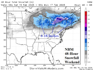
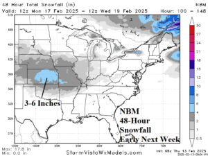
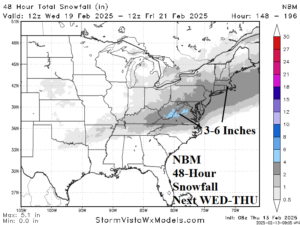
Fig. 5-7: The NBM 48-hour snowfall forecasts for 3 events ahead!