Mid-South U.S. Flash Drought Followed by Some Relief After 10 Days
07/31/2024, 11:13 am EDTMajor Excessive Rainfall and Flooding Episode for Southeast/East U.S. Ahead!
08/04/2024, 7:45 am EDTHighlight: 97L forecast to drift into very warm waters of the northeast Gulf of Mexico; HWRF forecasts a category2- hurricane.
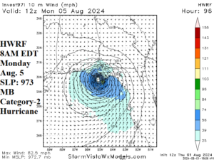
Fig. 1: The upper air pattern forecast by GFS for days 6-10 indicates a “col” located over Georgia and Florida. A “col” is an area of very light wind. The GFS
Discussion: The 12Z HWRF hurricane forecast model indicates Tropical Disturbance 97L strengthens to a tropical cyclone southwest of Florida Sunday morning. The next tropical cyclone is named Debby. HWRF turns Debby north-to-northwestward as a hurricane in the northeast Gulf of Mexico Sunday evening. Continued intensification is forecast by HWRF to a category-2 hurricane reaching the eastern Florida Panhandle by 8AM Monday morning (Fig. 1). This system has a massive amount of thunderstorm activity associated with the disturbance over Hispaniola today. The concern is that the low-pressure area holds and reaches the very warm waters of the northeast Gulf of Mexico which easily allows this system to gain strength and become a hurricane. The northeast Gulf of Mexico SSTA are 87F/31C which is 1-2C warmer than normal (Fig. 2). Beryl became a category-5 major hurricane over 87F/31C water in the eastern Caribbean Sea during early July. Beryl rapidly regained strength over 87F/31C waters just off the Texas Coast. Beryl was an overachieving damage producer moving inland across southeast Texas due to the last-minute encounter with very warm ocean water prior to landfall.
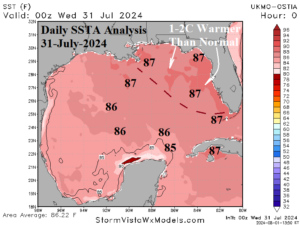
Fig. 2: Daily Gulf of Mexico SSTA analysis identifies the warmer than normal water surface in the northeast Gulf of Mexico.