Dry/Hot Pattern Accelerating East Europe/West Russia Drought SLOWLY Fades in September
08/29/2024, 3:51 am EDT-AO/-NAO Bring Autumnal Air Mass to Midwest U.S. Days 6-10
09/02/2024, 6:37 am EDT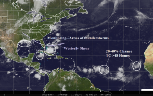
Fig. 1: North Atlantic basin tropics and subtropics weather satellite view.
Discussion: Many areas of thunderstorm activity are monitored for possible development this morning across the North Atlantic tropics/subtropics (Fig. 1). Two tropical waves in the east-central/far eastern tropics have between a 20% and 40% risk of becoming tropical cyclones after 48 hours. Thunderstorm areas in the Southern Bahamas, Western Caribbean, and Northwest Gulf are unlikely to become tropical systems (for now). Climate Impact Company lowered seasonal activity in an update on Aug. 27. However, 12 storms, 8 hurricanes, and 5 intense hurricanes remain in the forecast for SEP/OCT/NOV 2024. These numbers are impressive but substantially lower than other operational forecasts by Colorado State University and Tropical Storm Risk/U.K. A schematic identifying the required activity sequence for SEP, OCT, and NOV based on the CIC forecast vs. normal reveals a reliable range of possibilities for each month until the season ends on Nov. 30 (Fig. 2). Aside from seasonal forecasts, a schematic demonstrating what to normally inspect is indicated in Fig. 3.
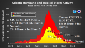
Fig. 2: The NOAA/NHC tropical cyclone climatology with the monthly likely amount based on the CIC forecast vs. normal for SEP, OCT, and NOV.
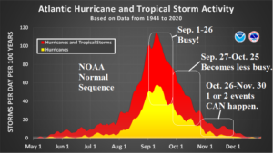
Fig. 3: What to normally expect during the second half of the North Atlantic tropical cyclone season.