Impressive Cold Pattern Change in U.S. Based on 12Z GFS
11/15/2023, 12:34 pm ESTEurope Flips Wet Extremes for Cold
11/19/2023, 1:10 pm ESTHighlight: ENSO and extreme cold risk in Texas review.
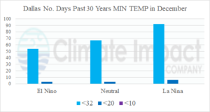
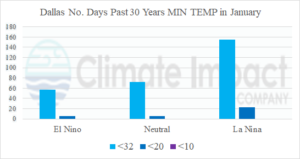
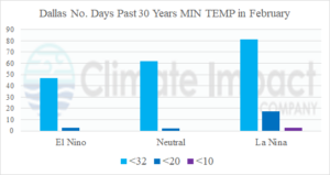
Fig. 1-3: The “most likely” temperature anomaly projection in 15 days features cold risk in the East U.S. and Europe.
Discussion: The ERCOT ice storm “Uri” occurred February 13-17, 2021, during a La Nina winter. During the past 30 years, coldest risk during winter in Dallas, TX strongly favors presence of La Nina. The bias appears in each month of meteorological winter (Fig. 1-3). “Uri” inspired the coldest risk (minimum temperature <10F) to Dallas, TX during February. La Nina winter features expanding snow cover across the northwest quadrant of the U.S. which can approach Texas after mid-winter increasing severe cold risk. El Nino years bring just the opposite effect on extreme cold as snow cover to the north is diminished and the ability to produce extreme cold in Texas lowers sharply. The number of mornings during winter when minimum temperature is <32F in Dallas is about 60% of the La Nina value. While extreme cold risk to Texas is diminished during El Nino winter, cloudiness (and precipitation) increases causing persistent cooler than normal daytime temperatures.