Texas Cold Risk Vs. ENSO Phase
11/17/2023, 8:03 am ESTStratospheric Warming Appears in 15 Days
11/21/2023, 9:51 am ESTEurope/Western Russia discussion: November 2023 has produced a soaking wet climate across much of Europe. In the wet zone, rainfall amount has ranged from 2 to 7 times normal during the past 30 days according to NOAA/CPC. Soil moisture conditions across Europe (and Western Russia) have turned sharply wetter as any late summer 2023 soil moisture deficits are (mostly) erased. Causal to the super wet pattern is an elongated deep upper low-pressure trough extending across the Northern Atlantic through Europe. The likely catalyst of this low-pressure area is a persistent presence of the convection phase of the Madden Julian oscillation (MJO) extending from the eastern equatorial Pacific, across the tropical Atlantic, and into tropical Africa. Latent heat release of convection over much warmer than normal tropical SSTA poleward and into the seasonal cooling of the atmosphere of the northern latitudes as winter approaches caused sharp thermal gradient enabling conditions for an extraordinary upper trough to develop and cause extreme rainfall in Europe. This week, high pressure builds across Western Europe as the energetic trough shifts east. In the 6-10-day period, the upper trough expands across Europe to bring another extreme: Early season chill. At night, widespread teens are likely in Western Russia with 20’s South-central Europe to Poland and Romania.
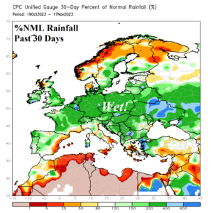
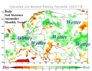


Fig. 1-4: The percent of normal precipitation across Europe during the past 30 days and daily soil moisture anomaly analysis (top). The 30-day 500 MB Anomaly pattern and 12Z GFS 6-10-day cold forecast for Europe (lower).