The Rains of Australia
04/18/2022, 5:21 am EDTWaters off the Northwest Coast of South America Observe Coolest Anomaly (-1.9) Since July 2013
04/25/2022, 10:02 am EDT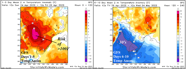


Fig. 1-2: The U.S. 180-day precipitation anomalies and percent ranking of current U.S. soil moisture anomalies.
Discussion: Climate forecasts have indicated widening drought in the Central U.S. for the upcoming warm season. Part of that forecast based on long-term precipitation trend across the U.S. The 180-day precipitation anomaly forecast for the U.S. indicates excessive dryness in the West, particularly northern California and the central/south Great Plains to Texas (Fig. 1). Dry climate during the past 180 days is also indicated in the Coastal Gulf States to the East Coast. As a result, soil moisture rankings reflect historic dry character in the West, Montana, and central Great Plains to Texas (Fig. 2). The dryness described is based on long-term trends. Unless a significant change in the climate pattern occurs (such as ENSO phase), the long-term climate is resistant to change. While dryness is expected to emerge during the warm season, the modern-day springtime La Nina climate is biased wet across U.S. spring wheat and soybean-growing zones. This region observes wet weather in the 15-day outlook, particularly in the 6-10-day forecast (Fig. 3). Additionally, due to the cold trough aloft producing these precipitation events, additional heavy snow is likely for the Dakotas (Fig. 4).


Fig. 3-4: The GFS ENS 15-day percent of normal precipitation forecast and the 24-hour change for the U.S. AG Belt.
An intense negative phase of the Antarctic oscillation (-AAO) is forecast for this week. As a result, an unusually intense upper trough is forecast to evolve over Southern Argentina. To the north of that trough, dynamic forcing causes excessive heat to develop in central South America. Centered on Paraguay and far northern Argentina temperatures >100F this week (Fig. 5). However, the much cooler air mass to the south roars northward in the 6-10-day period when northern Argentina night temperatures trail-off into the 30’s (Fig. 6). During the dramatic temperature changes, the bulk of the attendant rainfall is in Southeast Brazil to Uruguay while surrounding areas are dry (Fig. 7).


Fig. 5-6: The GFS 1-5-day temperature anomaly forecast features excessive heat in Paraguay followed by 6-10-day cool surge through Argentina.

Fig. 7: The GFS 15-day precipitation anomaly forecast across South America.
Dominant in 2022 (so far) is persistence of the negative phase of the Scandinavia Index (-SCAND). The -SCAND pattern is present when an upper trough is anchored over Northwest Eurasia. All forecast models indicate -SCAND developing this week and last lasting through early May. As a result, the 15-day forecast indicates another cool surge across North and East Europe plus West/Northwest Russia ahead (Fig. 8). The cooler weather also implies a drier than normal regime as subtropical moisture is cutoff from the prevailing westerlies aloft.


Fig. 8-9: The GFS 15-day temperature anomaly and 15-day percent of normal precipitation forecast across Europe and Western Russia.