South America Drought is Worsening Especially in Argentina
02/05/2024, 5:56 am ESTWestern Europe Rains in the Forecast (Mostly) Miss Northwest Africa Drought
02/09/2024, 8:36 am ESTDiscussion: During the past several weeks the Argentina climate has reversed hotter and drier than normal. The past 7 days observed continued lack of rainfall in Argentina and Southeast Brazil (Fig. 1) causing soil moisture conditions in Brazil to continue to deteriorate while Argentina soils are also trending somewhat drier (Fig. 2). There is good news in the forecast for Argentina. A stalled Madden Julian oscillation (MJO) in the central tropical Pacific Ocean (Fig. 3) has an influence on South America climate (Fig. 4) that increases vertical motion (convective clouds/thunderstorms). Consequently, forecast models indicating a wetter pattern change across Argentina much of the next 15 days (Fig. 5) is supported.


Fig. 1-2: The past 7 days percent of normal rainfall and the daily soil moisture anomaly analysis.
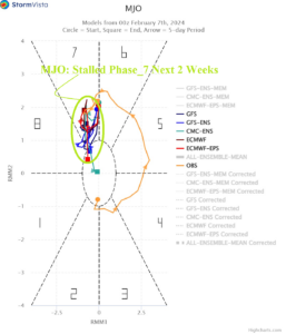
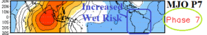
Fig. 3-4: Stalled Madden Julian oscillation phase_7 in the central tropical Pacific Ocean provides a wet bias across South America.

Fig. 5: The GFS 15-day percent of normal rainfall forecast across Argentina.