Southeast Europe/Black Sea Region Drought Continues
07/17/2024, 8:31 am EDTWhen Will the North Atlantic Tropics Turn Dangerously Active?
07/21/2024, 8:37 am EDT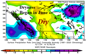
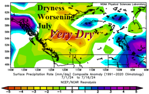
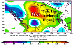
Fig. 1-3: Rainfall anomalies in June and the first half of July (upper) plus the first half of July temperature anomalies in Western Canada.
Discussion: In June, the climate pattern just east of the Canadian Rocky Mountains and across much of the Canadian Prairies turned somewhat drier than normal (Fig. 1). The June pattern was quite cool. In July, the dryness expands and intensifies (Fig. 2). However, with the established dry climate, anomalous heat has developed and accelerated through the first half of July (Fig. 3). Emergence of the suddenly dry and hot climate is in-part due to a marine heat wave northeast of Hawaii shifting northeastward to the West Canada Coast during the past month (Fig. 4). In the upper atmosphere, the warming ocean is reflected in the upper air pattern as an amplified high-pressure ridge has formed just off the Southwest Canada Coast (Fig. 5). The high-pressure area has caused the dry and hot climate in Western Canada including the Canadian Prairies. The jet stream axis on the back side of the polar vortex has forced the hot weather days (near 35C) in July. Looking ahead to August, the Climate Impact Company constructed analog (CIC-CA) temperature and precipitation outlook maintains the anomalous warmth although not quite as extreme (Fig. 6). Presence of the anomalous warmth is likely to maintain drying of soils despite some patchy shower activity (Fig. 7). In September, the CIC-CA forecast supports an ongoing soil moisture deficit trend as the climate pattern averages very warm and mostly dry (Fig. 8-9). Evolving drought in the Canadian Prairies and above normal fire risk for late summer/early autumn in Western Canada is likely over the next 4-8 weeks.
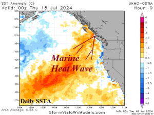
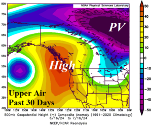
Fig. 4-5: A marine heat wave northeast of Hawaii has shifted northeastward to the Western Canada coast. The attendant upper air pattern during the past month identifies a hot and dry climate producing upper-level high pressure ridge on the Canadian West Coast.
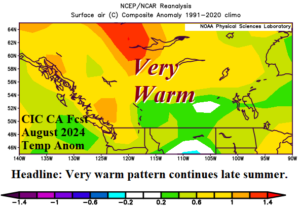
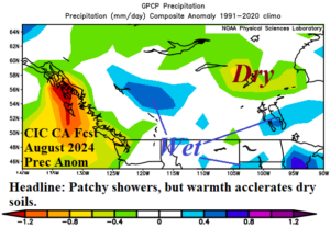
Fig. 6-7: The Climate Impact Company constructed analog temperature and precipitation anomaly forecast for August 2024.
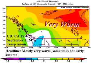
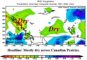
Fig. 8-9: The Climate Impact Company constructed analog temperature and precipitation anomaly forecast for September 2024.