The Climate Drivers Leading to Historic Flooding in Brazil
12/28/2021, 4:57 am EST
Knowing U.S. Springtime La Nina Rainfall Patterns
03/01/2022, 1:50 pm ESTExecutive summary: Adverse climate affecting crop production is often blamed on the ENSO regime. La Nina is in-place now and cited for causing the harsh hot/dry warm season climate across Paraguay and Northern Argentina while Brazil has observed unrelenting rainfall. La Nina has certainly continued to these climate regimes. However, a relatively new aspect of global ocean climate and influence on the upper atmosphere which leads to sensible weather patterns is likely a larger catalyst to the Argentina/Paraguay/Brazil hostile climate regime rather than La Nina. Specifically, the emergence in recent years of large anomalous warm SSTA regions mostly in the middle latitudes and referred to by climate scientists as “warm blobs” are leading to regional weather patterns that can cause extremes and are not necessarily related to ENSO. The Argentina/Paraguay/Brazil extreme climate of the 2021-22 warm season is mostly shaped by this new phenomenon.
Discussion: The meteorological summer 2021-22 climate across Argentina to Brazil has produced harsh extremes adversely affecting crops. During the summer season so far, anomalous heat has accelerated dry soils in Paraguay, northern Argentina to far southeastern Brazil (Fig. 1). Most of summer has featured very dry climate in this region (Fig. 2). Conversely, excessive rainfall beginning last spring has persisted over much of central and eastern Brazil. The second of two La Nina events emerged last September (according to NOAA) and continues in early 2022 and is generally blamed for the climate pattern described. However, the climate pattern has unique characteristics related to other aspects of climate (somewhat unique to recent years) and possibly a larger contributor to the Argentina/Brazil summer climate of 2021-22 (so far) than La Nina.
The wet pattern in Brazil is due mostly to a semi-permanent upper-level low-pressure trough just southeast of Brazil present since last spring (Fig. 3). The upper trough has a northwestward extension into Brazil causing the consistent instability to drive heavy rains. Meanwhile, to the south of the upper trough, a semi-permanent upper-level high-pressure system is in-place also extending northwestward (at times) to enhance the Paraguay/Argentina dryness. Helping to enhance the Brazil precipitation is a very warm Tropical South Atlantic (TSA) index which was at historic warm levels JUL/AUG/SEP last year and although not as strong certainly lingering into early summer 2021-22. Across the warm South Atlantic tropics, trade winds have carried above normal low atmospheric moisture into the Brazil trough pattern to make the observed rainfall more extreme.
The atmosphere is constantly in a state of compensation. The heavy convective rains in Brazil caused the compensating atmospheric subsidence to the south across Paraguay and Argentina to induce hot temperatures, lack of rainfall and drought. This phenomenon is separate from La Nina.
The climate pattern described is well-correlated to the 90-day global SSTA analysis (Fig. 4). La Nina is well-established. But note a relatively new phenomenon, extremely warm SSTA regions in the mid-latitudes of both hemispheres sometimes referred to by climate scientists as “warm blobs”. Across these regions of warm SSTA semi-permanent upper-level high-pressure ridge areas are common as previously identified across Southern Argentina extending east (and westward). These upper-level features are independent of ENSO and can induce other upper- level features to compensate for the strength of the high-pressure ridge. In this case, the upper trough southeast of Brazil. Again, this phenomenon is not necessarily related to La Nina.
All La Nina climate regimes are not the same. However, the past 10 years during DEC/JAN when La Nina was present has (on average) produced a South America climate with a hot bias in Northeast Brazil and the central coast of Argentina while the precipitation bias has been very wet over northwest continent (Fig 5-6). The DEC/JAN 2021-22 climate pattern is unique and possibly more related to the mid-latitude SSTA pattern(s) and their influence on the persistent upper air features driving the UNIQUE climate of summer 2021-22 (so far) across South America.
Summary: An unusually hostile climate pattern has emerged in South America during the 2021-22 warm season. Anomalous heat and dryness have propelled a drought in Paraguay to Southeast Brazil to Northern Argentina while excessive rains have plagued Brazil. While La Nina has contributed to this pattern, the more likely specific catalyst is the semi-permanent upper-level low-pressure trough southeast of Brazil extending northwestward into Brazil to cause convective rains compensated for by subsidence on the back side of that rainfall and centered on Paraguay and Argentina to cause just-the-opposite climate pattern – dryness and heat to accelerate drought. The South Atlantic SSTA pattern reveals a “warm blob” east of Argentina where an upper-level high-pressure ridge persists and to compensate for that ridge, the upper trough southeast of Brazil has formed. Up until recently, the entrainment of unusually wet trade winds in the tropical Atlantic enhanced by a vigorous warm tropical South Atlantic (TSA) index has enhanced the Brazilian rainfall caused by the upper trough. Important is understanding the emergence of an increasingly influential mid-latitude oceanic regime where regions of surface (and subsurface) water are unusually warm and can lead to regional climate extremes not necessarily related to ENSO.
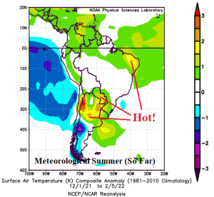
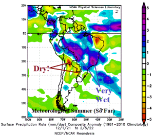
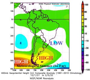
Fig. 1-3: The South America temperature anomalies and precipitation rate for Dec. 1, 2021 to Feb. 5, 2022 (top) and correlating upper air pattern using the 400 MB level (bottom).
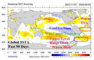
Fig. 4: The global SSTA analysis for the past 90 days revealing regional SSTA and their climate influences other than La Nina.
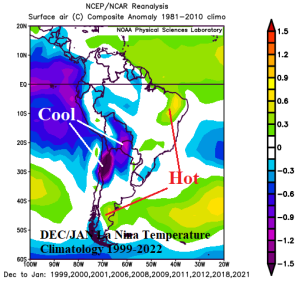
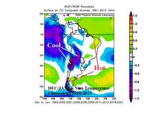
Fig. 5-6: The DEC/JAN La Nina temperature and precipitation anomalies for the past 10 episodes.

