“Warm Blobs” Shaping the Southern Hemisphere Early Summer Climate Pattern
11/28/2021, 10:01 am EST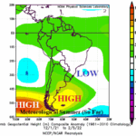
New Factors Causing Hostile Argentina/Brazil Climate Regime of Summer 2021-22 So Far
02/08/2022, 8:15 am ESTExecutive summary: Excessive rainfall during NOV/DEC 2021 across the same areas in west, central and east Brazil has caused historic widespread flooding. The rainfall totals during the past 30 days across this stretch are in the 10-20 in. range. Bahia is hardest-hit where up to 20 fatalities were reported by Dec. 27th. The heavy rain is blamed on a persistent cutoff low-pressure system off the Southeast Brazil Coast. More recently, a new cutoff low-pressure system has emerged to the west of northern Chile helping to broaden the widespread Brazil heavy rainfall pattern. The upper-level features leading to the Brazilian rains are not likely to change much into January as the mega-cluster ensemble maintains excessive rains in Brazil. Not far away, there are drought concerns for summer 2021-22 in Northeast Argentina/far Southeast Brazil. Dramatic climate extremes are raising havoc in South America.
Discussion: The rainfall amount for the past 30 days (through Dec. 26, 2021) has ranged from 10-20 in. across the Amazon Basin in west/central Brazil eastward through Bahia (Fig. 1). Surrounding the arc of heaviest rainfall is an area of several in. of rain to as much as 10 in, of rain in Southwest Brazil to the Upper Southeast Coast plus most of Northern Brazil. The heaviest rain is recent as the past 7 days have produced 4-10 in. of rain centered on Bahia where deaths from drowning and damage are greatest (Fig. 2). The heavy rain is caused by a semi-permanent upper trough southeast of Brazil (Fig. 3) entraining moisture off the warmer-than-normal South Atlantic tropics. The heavy rain arc has expanded westward across Brazil due to the emergence of a second upper-level low-pressure trough west of northern Chile. The warm waters in the South Atlantic tropics are cooling after record anomalous warmth a few months ago. A possible contributor to the heavy Brazil rains is the energy released to the atmosphere by the cooling tropical SSTA interacting with the two upper-level low-pressure systems described.

Fig. 1: The observed rainfall amount across South America the past 30 days.

Fig. 2: The observed rainfall amount across South America the past 7 days.

Fig. 3: The December 2021 upper air pattern across South America identifies two cutoff low-pressure systems north of a blocking high-pressure area. The two low-pressure systems are catalysts to the historic Brazilian rains.

Fig. 4: Global SSTA analysis and SSTA regions influencing the upper air pattern near and across South America leading to the Brazilian rains.
As always, the distinct upper air features leading to the Brazilian floods can be reflected in SSTA pattern. Warm SSTA stretch across the South Pacific recently reaching the Chilean Coast (Fig. 4). Meanwhile, persistent warm SSTA along the East Coast of Argentina extend across the mid-latitude South Atlantic. During December, a titanic high-pressure system stretched across this warm water zone and the attendant generally clear sky helped warm the ocean surface further. The atmosphere is in a constant state of compensation. Consequently, north of the high-pressure ridge are the two cutoff low-pressure systems previously described and their attendant storminess causes the SSTA in those regions to cool too normal or cooler than normal.
Oceanic conditions described are slow to change. Consequently, the rainfall pattern intact is likely to continue! The mega-cluster ensemble indicates more extreme rainfall in East Brazil in the 1-5-day outlook (Fig. 5), easing slightly but not ending in the 6-10-day forecast (Fig. 6) and re-energizing in the 11-15-day period (Fig. 7).


Fig. 5-7: Mega-cluster ensemble 15-day rainfall forecast across South America.
Conclusion: Drought concerns for Northeast Argentina to far Southeast Brazil have been highlighted in recent reports. As described in this report, the atmosphere has a tendency to compensate for extremes by producing the exact opposite climate in a nearby location. This scenario is expected for summer 2021-22 in South America where dry-to-drought conditions develop in Argentina and possibly reach Southeast Brazil. However, the short-term concern is with the excessive rainfall pattern just to the north…across west-central-east Brazil. During the past 30 days rainfall totals in this stretch have reached 10-20 in. and more heavy rain is on the way. The worst flooding in history is reported in Bahia. Expansion of these extreme flood conditions are likely into January.