New Factors Causing Hostile Argentina/Brazil Climate Regime of Summer 2021-22 So Far
02/08/2022, 8:15 am ESTAn Update on The El Nino Southern Oscillation 2022
03/24/2022, 8:36 am EDT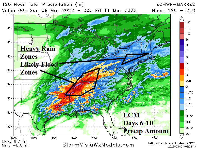
Discussion: To determine the most likely location/region for highest flood risk in the U.S., especially east of the Continental Divide determining where soil moisture is highest using Palmer Drought Severity Index (PDSI) and La Nina spring climate expectations is reviewed. Right now, areas with PDSI of +4.0 (or higher) which represents “extremely moist” soil moisture conditions with implications of additional rain, especially heavy rain can cause flooding to occur is located over Tennessee, northern Alabama, northeast Indiana and south-central Michigan plus parts of Pennsylvania, New York and Massachusetts (Fig. 1). Northeastern South Dakota soil moisture is also extremely moist.
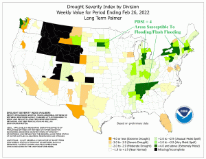
Fig. 1: Feb. 26, 2022 Palmer Drought Severity Index highlighting very wet areas.
Mature phase La Nina is in-place. La Nina is forecast to linger through spring 2022. La Nina springtime climatology since 1950 typically renders a dry national climate (Fig. 2). Wet zones are typically confined to the Coastal Northwest and Alabama to Appalachia. The northern Great Plains are also typically wet. However, the trend of the past 2-3 decades is wetter during La Nina in spring. The wetter climate is attributed primarily to warmer mid-latitude oceans (Fig. 3-4). According to NOAA, the modern-day La Nina springtime precipitation climatology is wet from Arkansas to the Tennessee Valley and northward across the eastern Ohio Valley and Great Lakes region.
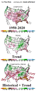
Fig. 2: NOAA historical, trend and historical + trend climatology of U.S. springtime La Nina precipitation.
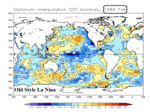
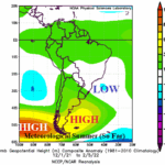
Fig. 3: The old La Nina pattern(s) when global oceans were cooler.
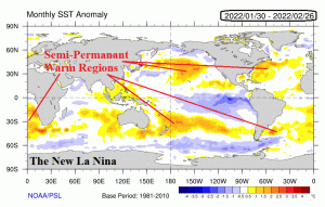
Fig. 4: Modern-day La Nina patterns when mid-latitudes have a tendency for broad anomalous warmth.
The current forecast indicates potential for excessive precipitation in the East-central U.S. in the 6-10-day period (Fig. 5) and based on the La Nina springtime historical + trend (climatology) the (wet) outlook is highly confident. ECM indicates several in. of rain to as much as 5-6 in. of rain causing high risk of flooding in the Tennessee Valley and vicinity. A flood risk is also issued for northern Pennsylvania to western Massachusetts. The timing of this event (according to ECM) is WED/THU of next week following a wet weather event early next week.
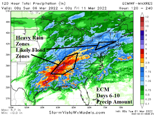
Fig. 5: The latest ECM projection of precipitation amount in the 6-10-day period.