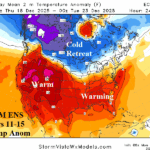
Cold Retreat, Operational/AI Models Warm U.S. Extended-range
12/08/2025, 4:27 am EST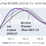
Adjusting Heating Demand Forecasts for Winter 2025-26 in U.S. and Europe
12/10/2025, 11:56 am EST![]()
December 2025 Climate Impact Company ENSO Outlook
Issued: Tuesday December 9, 2025
Highlight: La Nina shifts to neutral phase early 2026; El Nino in 2026 is likely.
Executive summary: La Nina has recently weakened. Some regeneration is possible for later this month/early January. However, the push toward warming by a recent intense MJO event suggests the weak late 2026 La Nina has peaked, and neutral ENSO generates for Q1/2026. The warming Northeast Pacific generated in-part by the recent intense MJO event requires monitoring. Often, warming of the Northeast Pacific is a precursor to an ENSO phase change toward El Nino. ECMWF and NMME (models) forecast El Nino onset during Q2/2026.
Discussion: An intense convection phase of the Madden Julian oscillation (MJO) developed over Western Maritime Continent during November. The episode triggered widespread heavy rain in this region (Fig. 1) including several significant late season tropical cyclones (Kalmaegi and Fung-Wong in the West Pacific/Senyar and Ditwah in the East Indian). The convective event was considered significantly intense to release latent heat poleward via a Rossby Wave to warm the stratosphere on the Pacific side of the North Pole (Fig. 2). The stratospheric warming gradually strengthened over North America during late NOV/early DEC (Fig. 3) causing the troposphere beneath to compensate by contracting causing high surface pressure and arctic air generation released into the U.S. to start meteorological winter (Fig. 4).
The MJO shifted across the equatorial Pacific causing slight erosion of La Nina. The Nino34 SSTA has warmed slightly and is close to the La Nina threshold (Fig. 5) and the subsurface equatorial Pacific has warmed near the Dateline while the cool anomaly in the East Pacific subsurface has weakened slightly (Fig. 6). Additionally, the eastward shift of the MJO across the equatorial Pacific may have contributed to warming in the Northeast Pacific near the North America West Coast, unusual for early meteorological winter (Fig. 7). The southern oscillation index (SOI) spiked (very) negative during the Eastward shift of the MJO into the eastern equatorial Pacific recovering to a robust positive phase in recent days (Fig. 8). The +SOI emergence indicates the effects of the MJO, on the stratosphere in the polar region and on ENSO are fading.
The question becomes can a La Nina-like tropical regime redevelop to sustain cold ENSO into early 2026? MJO is expected to weaken and regeneration in the Indian Ocean/Maritime Continent favorable to cause equatorial East Pacific trade winds to up-well cool water and sustain La Nina is in question. Consequently, the weak late 2025 La Nina may have peaked and forecasts for neutral phase in early 2026 by most Nino34 SSTA models (Fig. 9) seem likely.
The (current) warming of the Northeast Pacific is important. Often, the precursor of an ENSO change toward El Nino is warming in this region. Some forecast models, particularly ECMWF and more recently NMME (Fig. 10-11), are indicating evolution of El Nino during Q2/2026. The trend toward El Nino potential during 2026 is increasing.
Similarly, a phase change in the Indian Ocean dipole (IOD) is possible in 2026. The recent strong -IOD is fading and a shift to neutral phase during Q1/2026 is forecast. ECMWF forecasts El Nino development and possible weak +IOD during Q2 2026.
Schematics

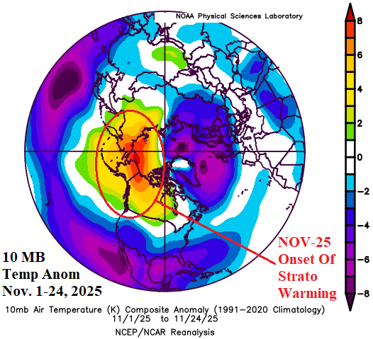
Fig. 1-2: The extreme rainfall across Maritime Continent and vicinity caused by a November 2025 strong convection phase of the Madden Julian oscillation. Latent heat release poleward from the convection initiated a stratospheric warming event on the Pacific side of the North Pole in November.
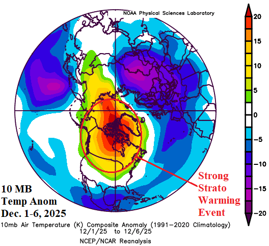
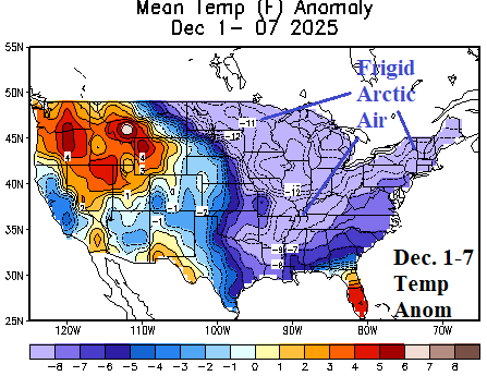
Fig. 3-4: The stratospheric warming became concentrated on Canada while strengthening in early December causing arctic air generation and an early December outbreak into the U.S.
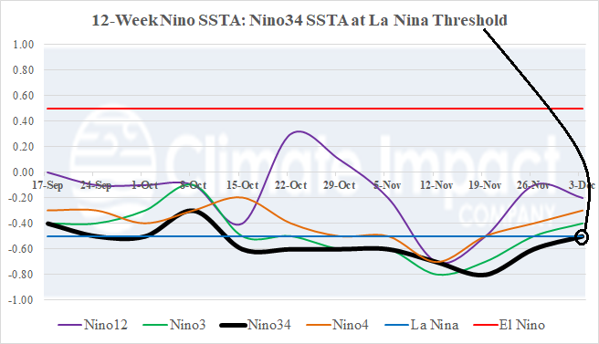
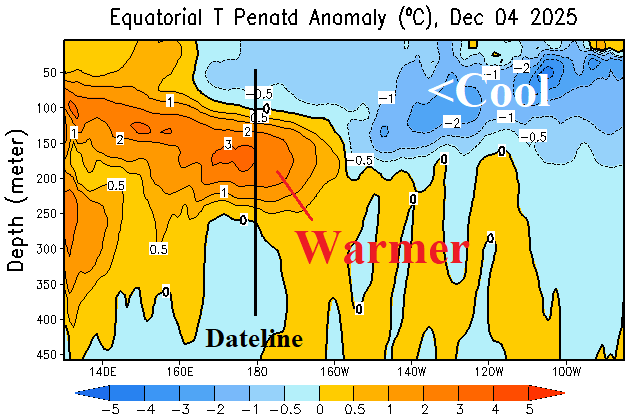
Fig. 5-6: The Nino34 SSTA warmed to the La Nina threshold while the subsurface equatorial Pacific Ocean warmed near the Dateline and is less cool in the East Pacific.
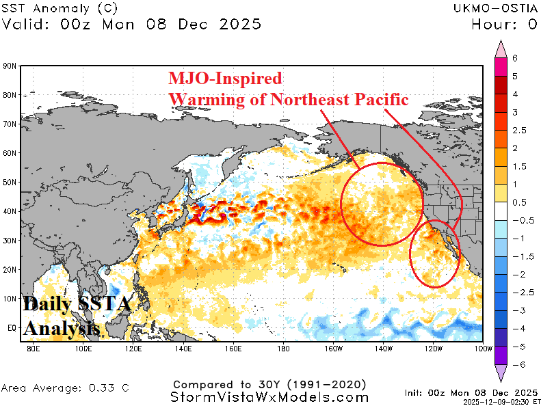
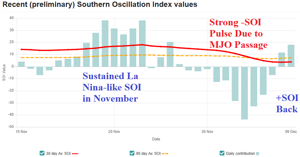
Fig. 7-8: The eastward MJO shift across the tropical Pacific helped to warm the Northeast Pacific SSTA as meteorological winter 2025-26 begins. The eastward MJO shift across the equatorial Pacific caused brief but strong negative phase southern oscillation index.
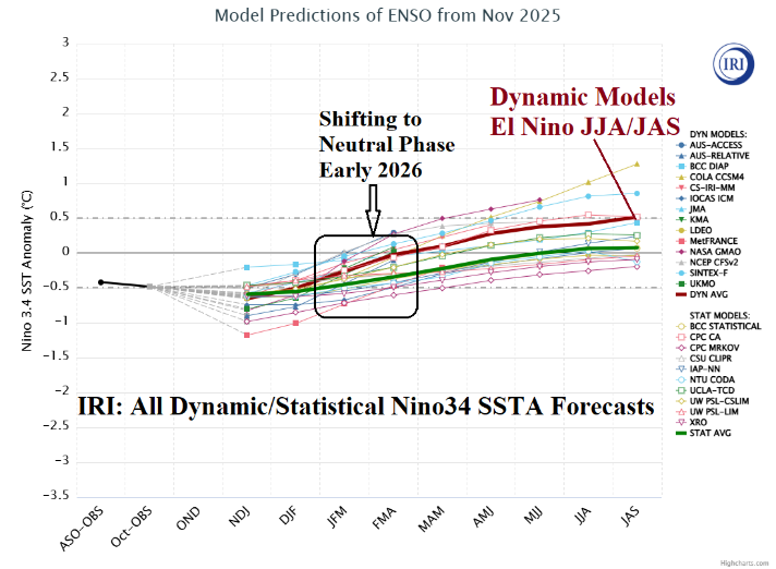
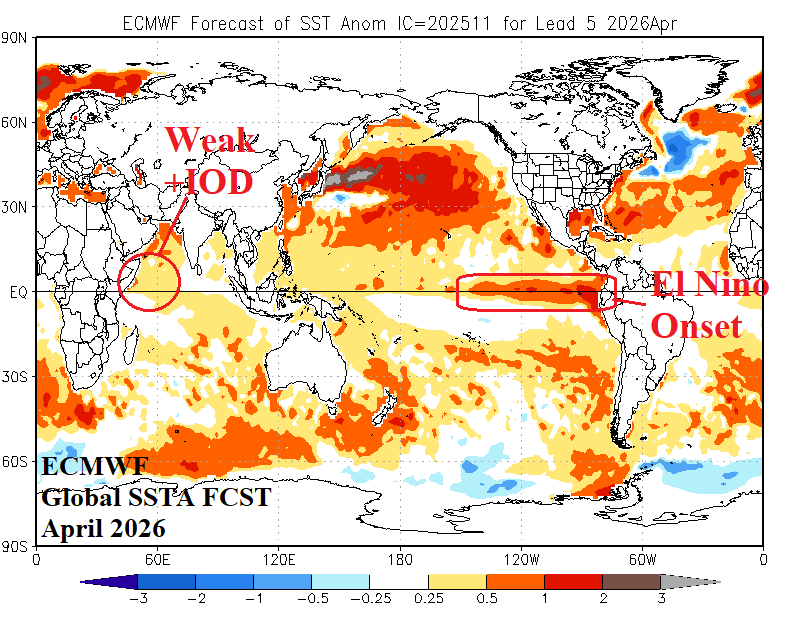
Fig. 9-10: The International Research Institute for Climate and Society collection of Nino34 SSTA forecasts generated by dynamic and statistical models reveals neutral ENSO for early 2026 while ECMWF global SSTA forecast for April 2026 indicates emergence of El Nino and weak +IOD.
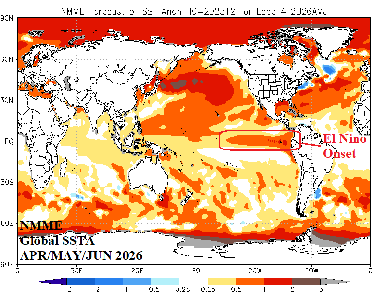
Fig. 11: The NMME model projects El Nino for Q2/2026.