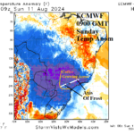
Overachieving Cold Event into Southern Brazil Coffee Areas
08/11/2024, 10:37 am EDT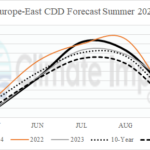
Europe Summer 2024 CDD’s…Staying Very Warm East
08/13/2024, 8:42 pm EDT
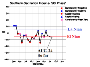
Fig. 1: The monthly southern oscillation index since October 2023. The SOI in August 2024 so far is -0.8.
Discussion: La Nina trajectories for later 2024 are not developing yet. The southern oscillation index is stubbornly in an El Nino phase so far in August after marginal El Nino-like observations in July and June (Fig. 1). The problem is surface pressure in the tropical East Pacific is not rising sufficiently and surface pressure in the far western Pacific tropics remains at normal level rather than lowering typical of La Nina. Normally 2-3 months of +SOI is needed to produce trade winds that can up-well cool subsurface water and initiate La Nina. There has been little or no +SOI tendency in 2024 so far and the most consistent El Nino-like -SOI is occurring in recent months (Fig. 2). Conversely, the subsurface equatorial East Pacific is cooling. In fact, the recent cooling returns the cool upper ocean heat anomalies to the levels observed last April. Normally, cool subsurface trend signals La Nina ahead. But! Trade winds needed to up-well cool water will not develop consistently until +SOI develops and is maintained. The Nino34 SSTA warmed slightly last week and remains in neutral phase (Fig. 3).
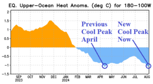
Fig. 2: The equatorial upper ocean heat east of the Dateline each month from the past year.
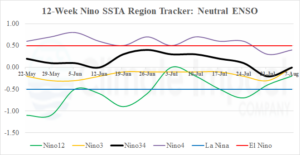
Fig. 3: The Nino SSTA regions during the past 12 weeks indicate steady neutral ENSO.