El Nino Fades; Speed of Development/Intensity of La Nina Ahead Uncertain
04/16/2024, 4:39 am EDTCooling Western North Atlantic Foreshadows Cooler East U.S. Coast Weather in May
04/26/2024, 4:35 am EDT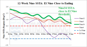
Fig. 1: The 12-week Nino region SSTA monitor identifying the steadily weakening Nino34 SSTA now very close to the El Nino threshold.
Discussion: The Nino SSTA regions continue to cool as the Nino34 index is very close to the El Nino threshold (Fig. 1). During May, ENSO will shift into neutral ENSO. In the subsurface, waters continue to cool in the equatorial Pacific east of the dateline (Fig. 2). The strength of the cool anomaly is strongly supportive of La Nina development after mid-year. The cool anomalies in the eastern equatorial Pacific subsurface suggest a rapid shift to La Nina if trade winds can up-well the chilly water to surface level. The southern oscillation index has averaged moderate negative phase during the past 30 days and is sharply negative today. The -SOI tendency indicates the ENSO climate remains in El Nino phase and resistant to a developing La Nina despite the cool subsurface equatorial Pacific. A large marine heat wave (MHW) is developing off the East Asia coastline and is strengthening (Fig. 3). Consequently, CFS V2 is forecasting a large high-pressure area to develop across the MHW during the summer season (Fig. 4). On the back side of the high- pressure area, a wet pattern may emerge in China.
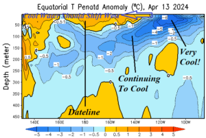
Fig. 2: Most recent NOAA/CPC temperature anomaly analysis of water beneath the equatorial Pacific region identifying increasing La Nina cool water supply.

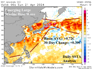
Fig. 3-4: A large marine heat wave is developing off the Asia Coastline. The strengthening warm anomaly should lead to anomalous high pressure during summer 2024.