Timing Mid-Atlantic Severe Weather Today
03/31/2022, 12:17 pm EDTBrazil and U.S. Drought Concerns
04/07/2022, 9:04 am EDT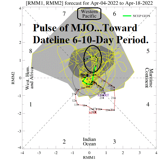
Highlight: MJO becomes important in regard to ENSO in early-to-middle March. If MJO shifts east (with subsurface warm water) La Nina could ends by MAY/JUN.

Fig. 1: North Pacific basin daily SSTA with regional annotations.
Discussion: The daily SSTA of key areas in the Pacific basin include a slight weakening (during the past 2 weeks) of the “warm blob” north and northeast of Hawaii (Fig. 1). The Nino SSTA regions are La Nina-cool but have warmed slightly the past 2 weeks just east of the Dateline while the farther east equatorial Pacific has cooled. In the subsurface, waters have cooled fairly dramatically the past several weeks in the Nino34 region while remnants of a Kelvin Wave remain off the northwest coast of South America (Fig. 2).
The next Kelvin Wave appears to be organizing in the West Pacific subsurface and has extended to east of the Dateline during the past couple weeks. Diagnostics reveal the presence of the convection phase of the Madden Julian oscillation (MJO) in the equatorial West Pacific. The GFS is projecting the MJO to shift east toward and possibly past the Dateline over the next 2 weeks (Fig. 3). If so, this process may be the catalyst to finish-off La Nina by mid-to-late quarter 2 of 2021.
Additionally, the MJO shift to or east of the Dateline would support anomalous warmth and wet (for the Great Plains) climate centered on the Central U.S. in the 11-15-day period.

Fig. 2: Subsurface equatorial Pacific Ocean temperature anomalies.
Fig. 3: Latest GFS 14-day Madden Julian Oscillation forecast.