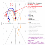
Onset of Climate Pattern Change Ahead Including La Nina Demise and ENSO Shift Toward El Nino
02/28/2023, 8:23 am ESTAn Update on Marine Heat Wave NEP22A
03/27/2023, 8:50 am EDT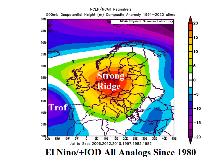
Executive summary: The combination of an impressive warm ENSO and positive Indian Ocean dipole is forecast by the Australia Bureau of Meteorology for JUL/AUG/SEP 2023. If so, analogs emphasize a strong upper ridge across Europe returning the dry/hot regime observed last year biased slightly farther eastward. The El Nino/+IOD pattern favors an upper-level anomalous warmth and dry climate-inducing regime over the North-central U.S. to possibly the Northwest States during this time.
Discussion: The latest Australia Bureau of Meteorology (ABOM) ENSO and Indian Ocean Dipole (IOD) forecasts feature sharp positive phase for mid-year. El Nino onset is in APR/MAY and strong El Nino emerges by JUL/AUG (Fig. 1). At the same time, an impressive +IOD also emerges (Fig. 2). Analog years (since 1980) producing El Nino/+IOD regimes are 1982, 1983, 1997, 2006, 2012, and 2015 (during JUL/AUG/SEP).
The 500 MB anomaly pattern for the analog years combined during JUL/AUG/SEP produces a RED FLAG upper ridge/drought risk for Europe (Fig. 3). Using the modern-day analogs (2006, 2012, and 2015) the upper ridge is centered on Ukraine (Fig. 4).
In North America, the analogs render a strong upper ridge over Central Canada to the North-central U.S. in-between upper troughs on both coasts (Fig. 5). This scenario could produce a North-central/Central U.S. drought concern. The modern-day analogs, the upper ridge exposure to the U.S. is across the Northwest while an upper trough occupies the eastern Ohio Valley (Fig. 6).
Elsewhere, an upper trough is produced by the analogs for much of China suppressing drought risk. In the southern hemisphere, a strong upper ridge resides just south of Australia while upper troughs emerge either side of Argentina replacing the persistent ridge patterns in this location during much of the past decade.
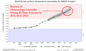
Fig. 1: Australia Bureau of Meteorology ENSO forecast.
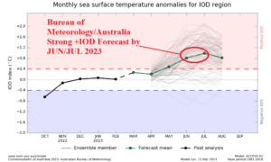
Fig. 2: Australia Bureau of Meteorology Indian Ocean dipole forecast.

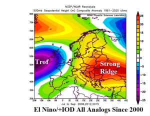
Fig. 3-4: El Nino and positive Indian Ocean dipole analog years since 1980 and the upper air pattern generated over Europe (left). Analog years since 2000 (right).

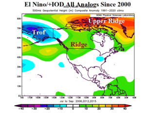
Fig. 5-6: El Nino and positive Indian Ocean dipole analog years since 1980 and the upper air pattern generated over North America (left). Analog years since 2000 (right).