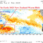
Marine Heat Wave is Catalyst to Historic Flooding and Heat During Summer 2022-23 in New Zealand
02/22/2023, 4:33 pm EST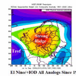
Strong El Nino/Positive Phase Indian Ocean Dipole Correlate to Europe Summer Drought
03/15/2023, 8:30 am EDT
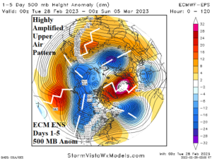
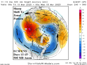
Fig: 1-2: The short-term 500 MB anomalies across the northern hemisphere and their pattern change in the middle latitudes in the 11-15-day period.
Discussion: The northern hemisphere upper air pattern has generally been highly amplified through the northern hemisphere cold season featuring a persistent stormy upper trough over the U.S. West Coast and Northeast Asia, super ridge over the marine heat wave (NEP22A) north-northeast of Hawaii, and equally impressive warm climate producing upper ridge areas over eastern North America and Europe. Heading into early March, the northern hemisphere upper air pattern remains quite amplified (Fig. 1). However, a large pattern change is ahead! In the 11-15-day period, ECM ENS indicates a reversal in mid-latitude upper air character (Fig. 2) to zonal (stronger west-to-east flow, less amplified). One sensible attendant weather pattern change is a broad colder shift in the U.S. The cause of this pattern change is an eastward shift of the Madden Julian oscillation (MJO) across the equatorial Pacific (Fig. 3) with intensity (for March) not seen since 2015. Following that event, El Nino developed. A rapid demise in La Nina 2020-23 will occur with this MJO transition over the next 2 weeks! The eastward shift of a strengthening MJO across the equatorial Pacific strengthens the positive phase of global atmospheric angular momentum (GLAAM) which erodes the amplified upper pattern of winter 2022-23 in middle latitudes (Fig. 4). The Australia Bureau of Meteorology adjusts their ENSO forecast to strong El Nino by JUL/AUG and El Nino onset as early as APR/MAY (Fig. 5).
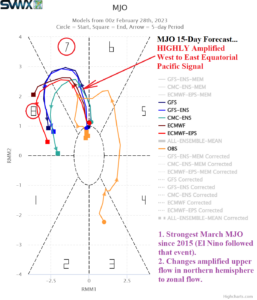
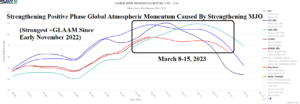
Fig: 3-4: The strongest March MJO event since 2015 is ahead and will contribute to the strengthening of a positive phase global atmospheric angular momentum.
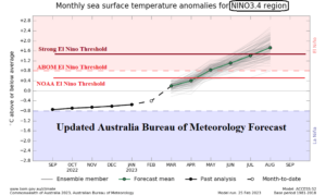
Fig: 5: Australia Bureau of Meteorology ENSO forecast using Nino34 SSTA.