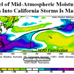
Explaining The “Atmospheric River” Evolution Into California
01/17/2023, 4:16 am EST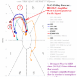
Onset of Climate Pattern Change Ahead Including La Nina Demise and ENSO Shift Toward El Nino
02/28/2023, 8:23 am EST
Marine heat wave brings historic rains and heat to New Zealand during summer 2022-23.
Executive summary: The most recent example of devastating climate regimes and embedded weather events is across New Zealand as summer 2022-23 has produced historic warmth across South Islands while Northern New Zealand has endured the worst flooding episode on record. The catalyst to the heat and flooding rainfall is the persistence of anomalous warm waters which reached record levels in early 2023 surrounding New Zealand. These “warm blobs” also known as marine heat waves have become more frequent and intense in both hemispheres during the past 10 years.
Introduction: Since 2017, exceptionally warm sea surface temperature anomalies (SSTA) associated with a marine heat wave (MHW) have centered near or just east of the Dateline in the South Pacific occasionally extending westward into New Zealand waters. The current MHW has produced record warm SST in New Zealand waters particularly off the west coast of South Island.
MHW’s are not new. However, their frequency and intensity have increased dramatically during the past 10 years most prominently in the Northeast Pacific but also in parts of the North Atlantic, West Pacific, and both the South Indian and South Pacific Oceans.
Climate Impact Company has noted that the influence on regional climate by these large areas of anomalous warm water are well-correlated to a warmer mid-atmosphere therefore above normal 500 MB heights which support a warmer/drier climate. Conversely, the warmer ocean surface also represents above normal low atmospheric moisture which if entrained into renegade upper-level low pressure troughs can lead to extreme rainfall events.
Additionally, tropical cyclones moving across MHW’s can strengthen quickly and become unusually powerful.
MHW’s produce a long-term climate pattern generally favoring anomalous warmth and dryness that can be interrupted by weather events producing the opposite extreme: Excessive rainfall. During early 2023, New Zealand has witnessed this opposite weather within a climate regime circumstance.
Discussion: During the 2017-2022 MHW centered just east of New Zealand, the 500 MB anomaly pattern reveals a persistent titanic upper-level ridge in the same location (Fig. 1). Speculated is the location of the high-pressure area and attendant warm SSTA near and east of New Zealand to the general neutral to cold phase of ENSO during this period (Fig. 2). In 2023 so far, the MHW has featured areas of record strength (Fig. 3) propelling a strong upper-level ridge although farther south this year than the 2017-2022 (MHW) climatology (Fig. 4). Frequently, MHW-inspired upper-level ridge areas are compensated by adjacent upper troughs. Consequently, the New Zealand summer 2022-23 climate was exposed to historic heat across South Island (Fig. 5) and the “biggest (flooding) climate event in New Zealand history” observed in Auckland (Fig. 6).
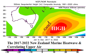
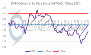
Fig. 1-2: The annual 500 MB anomaly analysis for 2017-2022 in the vicinity of Australia and New Zealand and tendency for neutral ENSO to mostly La Nina during that 6-year period.
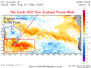
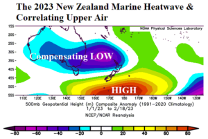
Fig. 3-4: The daily South Pacific SSTA analysis reveals the presence of the New Zealand MHW and the attendant summer 2022-23 upper air pattern.
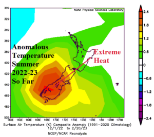
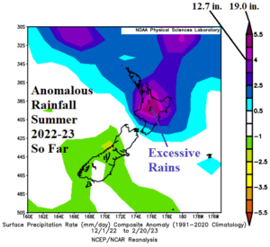
Fig. 5-6: The summer 2022-23 (so far) temperature and precipitation anomalies across New Zealand.
Conclusion: Marine heat waves have persisted in the vicinity of New Zealand since 2017. Due to the anomalous warm ocean water, the middle atmosphere has warmed as indicated by high-pressure ridging during this time centered just to the east of New Zealand. The summer 2022-23 MWH surrounding New Zealand reached record strength southwest of South Island. The farther south warm SSTA pattern was well-correlated to a shift in the subtropical ridge from just east of New Zealand to just south of the island nation. The upper ridge position was responsible for an unusually warm summer across South Island. Meanwhile, to compensate for the titanic upper ridge, a similarly intense low-pressure areas formed just-off the East Coast of Australia. The upper trough frequently entrained tropical moisture to unload historic rainfall on Northern New Zealand during the summer 2022-23 season. Included was the “biggest climate event in New Zealand history” which was a devastating flood centered on Auckland. MHW are not new, but their frequency and intensity has increased in both hemispheres during the past 10 years. Regions exposed to MHW climate have increased risk of hostile climate regimes and weather events. For more information on the New Zealand MHW’s please visit the New Zealand/NIWA or MOANA Project web sites.