La Nina Development Remains On Hold
07/02/2024, 12:53 pm EDTWet Pattern Ahead Squashes Texas Heat
07/13/2024, 6:06 am EDT 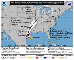
Fig. 1: Latest NOAA/NHC 5-day forecast track for Hurricane Beryl.
Discussion: At 8AM EDT, Tropical Storm Beryl is located at 25.5N/94.9W or about 220 miles southeast of Corpus Christi, TX. Beryl is moving northwest at 12 mph with top wind 60 mph and central pressure 992 MB. The NOAA/NHC 5-day forecast track (Fig. 1) is consistent although a little quicker to the coast and northeastward to the Ohio Valley. The intensity forecast at landfall remains a question.
As indicated yesterday, Beryl was not forecast to change in intensity for the 24-hour period ending now. However, the upper shear has weakened and off the Texas Coast upper shear is very light. The southwest shear ahead of a Central U.S. upper trough is seen well to the north of Beryl (Fig. 2). The light shear off the Texas Coast coupled with rapidly warming water which (Fig. 3) which is substantially warmer than normal (Fig. 4) leads the HWRF model to forecast a minimal cvategory-2 hurricane at landfall tomorrow morning across Matagorda Bay (Fig. 5). The HWRF was 5-6 MB too strong at initialization therefore 969 MB at landfall may be slightly too low. But! The model makes the point that preparations for a category-2 hurricane are warranted. NOAA/NHC maintains a moderate-strength category-1 hurricane model at landfall using a consensus between HWRF and the shy tropical cyclone model intensity forecasts.
The storm surge forecast has increased and is the most focused on Matagorda Bay where a 4-to-6-foot surge is forecast (Fig. 6). NOAA/NHC projects 8-12 in. of rain near and east of the landfall location (Fig. 7). Flood risk includes the central Texas Coast tonight and into the Houston area tomorrow plus much of eastern Texas to the Missouri Valley on Tuesday (Fig. 8).
Tropical storm force wind will extend outward to 100 miles northeast of the landfall location (Fig. 9). Hurricane force wind will extend to 20 miles northeast of the landfall location (Fig. 10). As always, maximum intensity is in the right-front quadrant relative to movement.
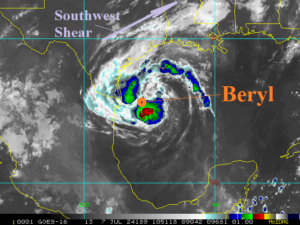
Fig. 2: Weather satellite view of Tropical Storm Beryl.
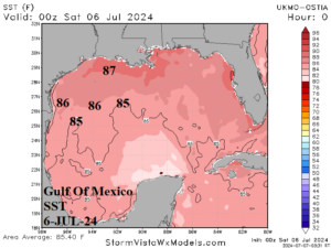
Fig. 3-4: Gulf of Mexico sea surface temperatures and sea surface temperature anomalies.
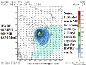
Fig. 5: HWRF landfall forecast for Beryl with notes.
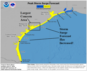
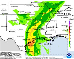
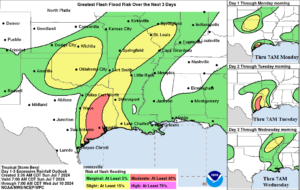
Fig. 6-8: NOAA/NHC storm surge and rainfall forecast associated with Beryl plus the flood risk areas.
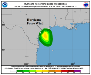
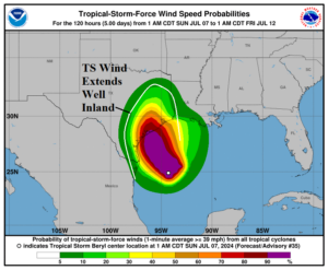
Fig. 9-10: NOAA/NHC hurricane and tropical storm force wind profile forecast.