Dry Soil Moisture Emerging In Australia
07/23/2023, 3:49 pm EDTHeavy Rains Heading for Europe
07/25/2023, 5:32 am EDTHighlight: 95L is drifting west with limited development. GFS is occasionally indicating an East Coast hurricane in the 11-15-day period.
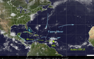
Fig. 1: Satellite view of the North Atlantic basin and primary features.
Today’s discussion: Tropical Disturbance 95L has gained convection as outflow aloft has increased (Fig. 1). The increased outflow is due to a shear axis just to the north of the disturbance. While the disturbance is larger, the ability to develop (due to upper shear) is limited. This system drifts westward this week with little development due to the upper shear continuing. In the outer tropical North Atlantic, the ITCZ is active. On occasion, the GFS and ECM develop a tropical wave within the ITCZ and carries the event west-northwest with development possible by late this week in the central North Atlantic tropics. GFS has produced two model runs that develop this system into a hurricane reaching the Mid-Atlantic Coast in 13 days (Fig. 2).
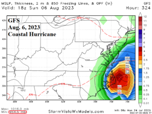
Fig. 2: GFS has produced 2 model run forecasts over the past couple days that indicate an East Coast hurricane risk.