Equatorial Upper Ocean Heat Foreshadows Climate Pattern Changes Ahead!
05/21/2024, 4:48 am EDTSevere Storms/Heavy Rain and Flooding Mid-south U.S. Continues
05/28/2024, 8:51 am EDT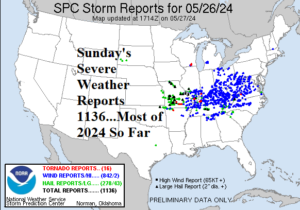
Fig. 1: Yesterday’s severe weather reports (1136), the most for any day in 2024.
Discussion: Nearly two dozen people have been killed due to severe weather this weekend from Arkansas and Oklahoma to Kentucky. Yesterday, the most severe weather reports of any day in 2024 so far were recorded (Fig. 1). Most of the 1,136 reports were damaging wind gusts although 16 tornado reports are included. Severe weather risk moves into the East today (Fig. 2). Activity is likely to get going later this afternoon and severe thunderstorm watch areas are likely. The best dynamics forecast for a tornado risk is across central/east-central Virginia. On Tuesday, severe weather convenes over western and central Texas (Fig. 3). A wet pattern unfolds for the southeast Great Plains where ECM forecasts up to 5 in. of rain for later this week and through the weekend (Fig. 4).
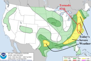
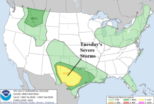
Fig. 2-3: Severe weather outlook for today and Tuesday.
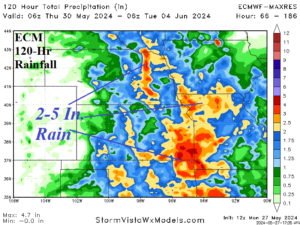
Fig. 4: The 5-day rainfall forecast by ECMWF valid for Thursday to next Monday.
The “most likely” temperature anomaly forecast is warm Interior West while the East is temperate (Fig. 5) followed by a big and large expansion warm-up in the West during the 11-15-day period (Fig. 6). The GFS at midday was quite cool in the East. The U.S. population weight CDD forecast indicates above normal cooling demand in the U.S. (Fig. 7).
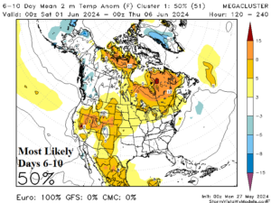
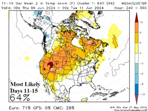
Fig. 5-6: The “most likely” temperature anomaly forecast using the mega-cluster ensemble for the medium range.
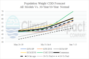
Fig. 7: U.S. population weight CDD forecast utilizing all models, their consensus, and comparison to 48 hours ago and the 10-year/30-year normal.