The Amundsen Sea Semi-Permanent Low-Pressure Trough
05/26/2022, 10:04 am EDT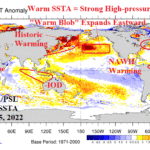
Effects on Climate of Warming Reginal SSTA
07/17/2022, 12:22 pm EDTModel Verification Indicates Recent Cooler/Wetter U.S. Forecasts Are Overstated


Fig. 1-2: June 2022 (so far) U.S. temperature and precipitation anomalies.
Discussion: So far, June 2022 is hotter and drier than normal for most of the U.S. (Fig. 1-2). The one exception is the Northwest U.S. where cool and wet conditions have persisted. Welcome wet weather has eased Florida drought. Elsewhere, especially in the Central U.S., dryness and heat has dominated. The June 2022 climate forecast from Climate Impact Company (CIC) was based on a constructed analog. CIC-CA forecasts are heavily biased toward mid-latitude SSTA patterns due to their increased influence on climate during the past decade. Of course, ENSO is also a significant factor. Soil moisture observations and trends are also heavily considered. The CIC-CA June 2022 forecast was aware of the South-central U.S./Texas heat and dryness and has the general warmer than normal national pattern which includes suppressed heat risk in the Northwest (Fig. 3). However, the Midwest and East U.S. forecast was too wet (Fig. 4). The drier pattern is attributed to the influence of large areas of soil moisture deficit on the general climate. Consequently, leading into mid-summer drought concerns have expanded (Fig. 5). Fortunately, for some areas, drought concerns may ease as the upper air pattern for the next 15 days changes and the prevailing mid-latitude westerly flow aloft entrains Southwest U.S. monsoon moisture to unload fast-moving thunderstorms across parts of the Central and East U.S. (Fig. 6). The pattern change described has been hinted at, especially by the GFS for nearly 2 weeks. Cooler temperature forecasts have eased back natural gas prices. The GFS continues to indicate a cool forecast for the North-central U.S. toward the Northeast States during the medium-range. One note of caution, the GFS temperature bias during the past 2 weeks has been much too cool in the North-central U.S. for medium-range forecasts, especially in the 11-15-day period (Fig. 7-8). Additionally, the West U.S. forecasts have been too hot! Previously, identified was a CIC-CA forecast for June 2022 too wet across the eastern states. Similarly, the operational models have that same wet bias. The GFS ENS medium-range forecasts are much too wet across the North and East U.S. for the past 30 days (Fig. 9-10). The problem is macro-scale drought and a dry trend is overwhelming the sensible precipitation pattern. So…although forecasts through the first third of July have trended cooler (less hot) and wetter, the forecast bias of operational models indicates these pattern changes are likely overstated.


Fig. 3-4: June 2022 (so far) U.S. temperature and precipitation anomalies.


Fig. 5-6: U.S. soil moisture percentile rankings for June 24, 2022 and the 15-day upper air forecast for North America by the ECM ENS.


Fig. 7-8: GFS temperature anomaly forecast bias the past 2 weeks for the medium-range.


Fig. 9-10: GFS ENS precipitation anomaly forecast bias the past 30 days for the medium-range.