Model Verification Indicates Recent Cooler/Wetter U.S. Forecasts Are Overstated
06/26/2022, 8:54 am EDT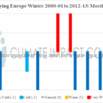
What Weather Pattern Makes a Cold Winter in Europe?
07/28/2022, 5:04 am EDT
Highlight: Mid-latitude warming of ocean surface to continue and become dramatic mid-to-late summer across northern hemisphere supporting increased drought/hot risk.
Executive Summary: As northern hemisphere mid-summer approaches, mid-latitude ocean waters are warming to much above normal levels off the East Asia Coast, north and northeast of Hawaii and east of the Northeast U.S. plus the Mediterranean Sea. ECMWF projects the warming to continue and intensify. Large areas of very warm sea surface temperature anomalies (SSTA) are well-correlated with stronger-than-normal high-pressure aloft which increases risk of drought and anomalous heat in the affected areas. We’ve already seen the influence of regionally warm SSTA surrounding Europe promoting high-pressure and the ongoing heatwave. Expect subtropical/mid-latitude high-pressure ridging to increase and strengthen causing developing drought to worsen in parts of East Asia to Japan and much of the U.S. plus Europe to the Black Sea region during mid-to-late summer. Conversely, negative Indian Ocean Dipole (-IOD) will drive a wet climate across Australia.
Fig. 1: Current global SSTA anomalies and regions of anomalous warmth.
Discussion: Typical of the past 10 years, mid-latitude SSTA pattern during mid-to-late summer becomes historically warmer-than-normal. Currently, waters off the East Asia coast may be approaching the warmest on record (Fig. 1). The North/Northeast Pacific “warm blob” has recently expanded eastward reaching the U.S. West Coast in recent days. The cool waters south-southeast of Greenland are blocking northeastward progress of the Gulf Stream causing oiling of warm waters off the Northeast U.S. coast to south and east of Nova Scotia. Super warm waters off the West and North Coast of Europe and especially the Mediterranean Sea are well-correlated to the Europe heat wave. Also of interest, recent warming across the deep tropics in the North Atlantic Basin. A rapidly developing negative Indian Ocean Dipole (-IOD) is developing northwest of Australia.
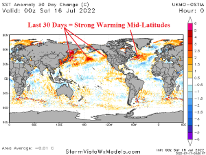
Fig. 2: The 30-day global SSTA trend identifies mid-latitude northern hemisphere warming.
The 30-day SSTA trend is MUCH WARMER off the East Asia Coast and north of Hawaii to North America West Coast (Fig. 2). Warming off Southeast Canada is also sharp! Stronger than normal high-pressure across these warm SSTA regions is causing faster-than-normal up-welling easterly wind which has cooled waters just north of Hawaii and south and east of Bermuda.
The September 2022 global SSTA forecast by ECMWF indicates the mid-latitude warming in the North Pacific will strengthen (Fig. 3). In the equatorial region, La Nina continues while the -IOD pattern becomes quite intense. The North Atlantic is mixed with very warm SSTA off the Northeast U.S. Coast and off Western Europe while the Sargasso Sea is temperate to cooler than normal.
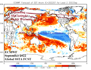
Fig. 3: ECMWF global SSTA forecast for September 2022 maintains warmer trend of SSTA in the middle latitudes.
Conclusion: Typical of the past 10 years, mid-latitude oceans warm sharply during mid-to-late summer. In 2022, the very warm mid-latitude ocean surface is emerging most dramatically depicted off the East Asia Coast. The Northeast Pacific “warm blob” is displaced westward toward the Dateline during the past year but recently expanded eastward to the North America West Coast. ECMWF indicates the already impressive warming of the North Pacific will continue. Indicated is support for anomalous high-pressure ridging across East Asia (including Japan) increasing the risk of very dry and hot conditions. If the warming off the West Coast of North America continues, risk of hot high pressure on the West Coast mid-to-late summer increases. In the North Atlantic, the SSTA outlook is mixed. Warming off of Southeast Canada and the Northeast U.S. Coast continues and implies emergence of high-pressure ridging in this zone. Anomalous heat and continued dryness is the result. High-pressure evolving in this region also sets-up steering currents for tropical cyclones toward the Gulf of Mexico and Southeast U.S.