Effects on Climate of Warming Reginal SSTA
07/17/2022, 12:22 pm EDTWhy Have Week-2 U.S. CDD Forecasts Been Too Hot?
08/02/2022, 5:42 am EDT
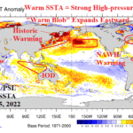
Executive summary: Before issuing the Europe winter 2022-23 climate outlook, a review of what makes a cold winter in Europe is reviewed. Wintertime since the turn of the century is examined. Results identify two regimes: A cold period for most of the first 13 winter seasons of this century and generally mild winter seasons during the past 9 years. During the first 13 years of this century wintertime typically brought high-latitude high-pressure blocking which forced a cold and snowy generating polar vortex across Europe or Western Russia during the winter season. Since winter 2012-13 the tendency for high-latitude high-pressure blocking has nearly disappeared. Instead, a persistent large upper-level low-pressure trough has formed west of Europe across a large area of relative cool ocean water. The upper trough is compensated for by an upper-level high-pressure ridge across Europe yielding mostly warm winter seasons during the past 9 years. The oceanic catalyst to the tendency for milder winter seasons in Europe is the North Atlantic Warm Hole (NAWH), an area of cool SST south and southeast of Greenland.
Discussion: What makes Europe colder than normal during winter? Understanding how Europe winter can become colder than normal in the modern climate era and whether the explanation can be applied to winter 2022-23 is paramount given the current increasing energy shortages in Europe ahead of the 2022-23 cold season. Let’s review the cold winter seasons of the current century in Europe.
The first cold winter in Europe of this century was in DEC/JAN/FEB 2002-03 (Fig. 1). As always, snow cover is the key to a colder than normal winter climate. In December 2002, an amplifying Greenland/North Atlantic high-pressure ridge (negative North Atlantic index) formed and to compensate, a downstream Western Russia upper trough also strengthened with a classic “polar vortex” signature. December 2002 was historic cold across Eastern Europe to Central Russia featuring monthly temperature anomalies of -10C in Moscow and eastward while Eastern Europe was almost as cold. January 2003 stayed cold although less extreme as marine influence from the North Atlantic were present at times. The blocking high pressure system returned in February across Northern Europe (positive Scandinavia index) and forced a cold low-pressure trough over Southeast Europe. Historic cold and snow regenerated across Central and Southeast Europe during February 2003. On average, meteorological winter 2002-03 was 3C-7C colder than normal in Eastern Europe.
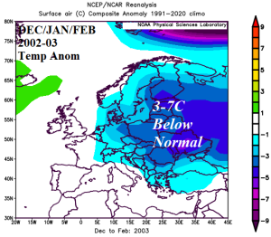
Fig. 1: DEC/JAN/FEB 2002-03 was much colder than normal across Central and Eastern Europe.
The next cold winter across Europe waited until 2005-06 (Fig. 2). Once again, blocking high-latitude high-pressure initially north of Europe during early winter gradually spread from Greenland to Northern Europe and caused very cold temperatures enhanced by snow cover across the southern 2/3 of Europe. Each winter month was cold with very limited mild breaks. The coldest anomalies were across the Eastern Europe/Western Russia border where snow cover was persistent.
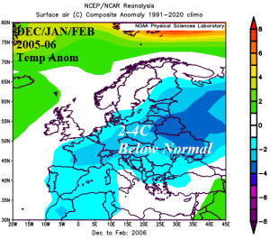
Fig. 2: DEC/JAN/FEB 2005-06 was much colder than normal across all but northwestern Europe.
During winter 2008-09, the colder than normal weather set-up was across Western Europe and most-focused on France (Fig. 3). Western Russia was not the source region for the winter chill. In December, an upper trough set-up over Southwest Europe to the south and southeast of blocking high-pressure amplified in Northwest Russia. Early winter was chilly and mostly wet across Southwest/South Europe. During mid-to-late winter, the upper trough remained and amplified causing an aggressive Southern Europe storm track of which the northern periphery of above normal precipitation fell as mostly snow. Mid-to-late winter was very cold across Southern Europe due to the influence of clouds and snow on prevailing temperature pattern. There was limited arctic air involved with this chill as the entire cold air regime was generated by a Southern Europe upper trough. This type of cold winter in Europe is rare.
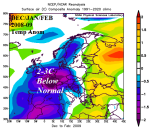
Fig. 3: DEC/JAN/FEB 2008-09 was much colder than normal across Central and Southwest Europe.
As usual, a cold early winter pattern starts with titanic blocking high-pressure from Greenland to the north of Europe. During December 2009, the consequence of the high-pressure block was a compensating large polar vortex dropping anchor over France. During mid-winter, the upper trough strengthened while budging eastward to South-central Europe. Due to the positioning of the upper trough, a low-level easterly flow of arctic air spread westward from Russia to Europe became established. Widespread snow cover enhanced the mid-winter cold which was most severe from Moscow to Oslo. In February, the upper trough shifted back to the North Atlantic and maintained a cold late winter regime across plentiful snow cover in Central and Northern Europe while some milder marine influences eased the big chill in Southern Europe. The winter season averages were 2C-5C colder than normal across most of Europe and into Western Russia (Fig. 4).
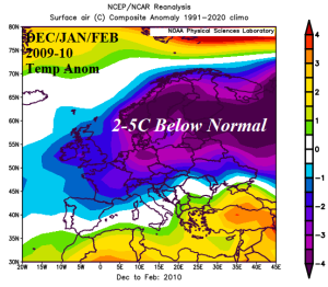
Fig. 4: DEC/JAN/FEB 2009-10 was much colder than normal across all of Europe and Western Russia.
DEC/JAN/FEB 2010-11 was the 5th cold winter across Europe during the past 10 years. This time, the big chill was most intense over Northwest Russia and extended across most of Europe (Fig. 5). Meteorological winter started with an intense Central Europe upper trough causing very cold weather (and plenty of snow) across all but far Southern Europe and included West/Northwest Russia. Early season arctic air was pulled westward by the upper trough into Europe. A thaw developed during January as temperatures recovered to near normal and most of the early season cold dissipated. January 2011 was the first winter month of the 5 cold winters noted so far when temperatures returned to normal. However, in February the “polar vortex” regenerated over Western Russia to inspire new arctic air and some of that air mass expanded westward into Europe.
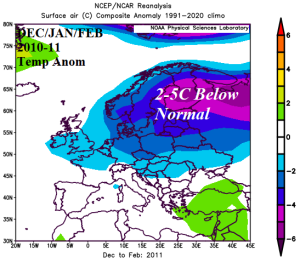
Fig. 5: DEC/JAN/FEB 2010-11 was much colder than normal across all Northwest Russia and into the northern 2/3 of Europe.
The following two winter seasons were marginally cold in some parts of Europe and near normal elsewhere. In fact, from winter 2000-01 to winter 2012-13 (13 years), only two winter seasons were warm across Europe (2006-07/2007-08). Since the turn of the century and up to winter 2012-13, Europe mostly observed cold winter seasons (Fig. 6).
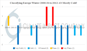
Fig. 6: Classifying winter season temperature across Europe from 2000-01 to 2012-13 yielded mostly cold regimes.
Since winter 2012-13 all Europe winter seasons have been near or warmer than normal (Fig. 7). Evolution of the North Atlantic Warm Hole (NAWH) during winter 2013-14 is the leading contributor to that pattern change (Fig. 8). Across the relative cool waters south and southeast of Greenland associated with the NAWH, a winter-time upper trough has persisted. The upper trough location across the vast North Atlantic has limited cold air generation due to marine influences. Downstream from the persistent upper trough a compensating upper ridge (Fig. 9) has left Europe with mostly mild winter seasons the past 9 years.
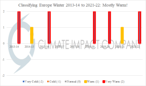
Fig. 7: Classifying winter season temperature across Europe from 2013-14 to 2021-22 yielded mostly warm regimes.
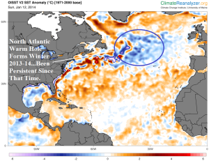
Fig. 8: A pool of cooler than normal water formed during 2013-14 to the south of Greenland in a surrounding ocean basin where the ocean surface is generally warmer than normal. The North Atlantic Warm Hole was born and has persisted with varying intensity the past 9 years while contributing to milder Europe winter seasons.
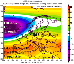
Fig. 9: Since formation of the NAWH during winter 2013-14, the upper air pattern has featured a cold upper trough across and just downwind the NAWH with a compensating (mild) upper ridge across much of Europe.
Conclusion: In the current century apparently two winter regimes have been observed across Europe. During winter of 2000-01 to 2012-13 a colder than normal winter was frequent (8 of 13 years). The cold winter seasons were attributed to high-latitude high-pressure blocking which forced a “polar vortex” over Europe or Western Russia to generate snow cover and following cold. The tendency of high-pressure to form to the north of Europe during this time is likely associated with the constricting polar ice cap and open water having a tendency to warm the atmosphere aloft to create high-pressure.
However, this persistent pattern changed, almost immediately beginning in winter 2013-14 when a large area of colder than normal water emerged south-southeast of Greenland made obvious by the tendency of surrounding warmer than normal water common across the North Atlantic basin since the emergence of the warm phase of the Atlantic multi-decadal oscillation (AMO) in the late 1990’s. The North Atlantic Warm Hole (NAWH) is attributed to surface (and deep) water changes in temperature and salinity caused by increasingly rapid ice melt from Greenland. The entire process remains not well understood. Possibly the tendency of persistent warmer high-pressure ridging in the high latitudes during the preceding 13 years lead to this condition.
The emergence of the NAWH caused milder winter seasons during the past 9 years. In fact, 7 of the past 9 winter seasons across Europe have been milder than normal. If NAWH persists for upcoming winter, the temperature regime across Europe is likely milder than normal and resists important cold.