Identifying The Brazil Drought Trend
12/19/2023, 4:46 am ESTSouthern Half of U.S. Looks Colder/Stormy First Half of January
12/21/2023, 5:42 pm EST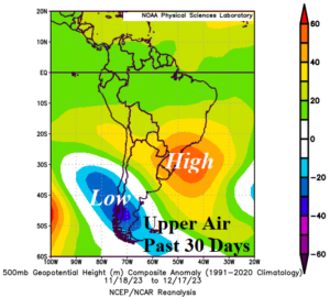
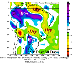
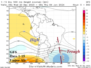
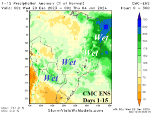
Fig. 1-4: The upper air pattern and attendant rainfall anomalies for the past 30 days (top) and 15-day upper air forecast and rainfall anomalies (bottom).
Discussion: During the past 30 days, an amplified subtropical high-pressure ridge has become semi-permanent off the Southeast Brazil Coast (Fig. 1). Sea surface temperature anomalies (SSTA) off the central South America Coast have warmed dramatically during this time. The rainfall anomalies across Brazil have mostly been drier than normal during the past 30 days (Fig. 2) accelerating drought concerns in South and East Brazil. Western Brazil rains have advanced eastward into Central Brazil. The 15-day forecast indicates a pattern change with upper air features affecting the Brazil rainfall (Fig. 3). Initially, the upper ridge relocates over Bolivia over the next few days. To compensate, an upper trough forms on Brazil’s East Coast and attendant rains drench Eastern Brazil. Increasing the rainfall intensity is the warm SSTA east of Brazil identified by a tropical South Atlantic (TSA) index averaging a robust +1.35C in December. In the medium-range, an upper-level trough in the middle latitudes amplifies east of South America to inspire additional heavy rain in East Brazil mostly in the 11-15-day period. The 15-day percent of normal rainfall forecast by CMC ENS identifies the rainfall pattern change extending to early January which is almost opposite of the past 30 days regime (Fig. 4).