South America Pattern Change Focused on Brazil
12/20/2023, 6:00 am ESTWhat A Rapidly Decelerating El Nino Brings To Major Crop Areas During MAR/APR/MAY and JUN/JUL/AUG 2024
12/26/2023, 2:49 pm ESTCharts of the day: AI vs. ECM in 10 days.
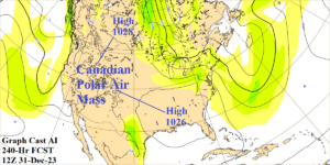
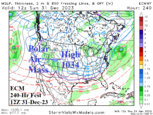
Discussion: We’re anticipating a colder pattern change in January. In 10 days, does Graph Cast AI (versus ECM) see any colder signs? The short answer is yes. Canadian polar air high pressure is projected by AI over Central Canada and the Mid-south U.S. Polar air masses are near to slightly below normal except colder when over snow cover. ECM indicates one polar high-pressure area with slightly more intensity centered on the Great Plains. In the scenario identified, coolest anomalies are likely over the Southeast U.S. No arctic air, but trending cooler.
Week-2 Ahead Forecast valid January 2-8, 2024: Ominous Southwest U.S. storm track.
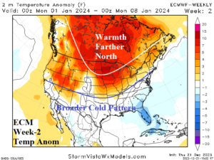
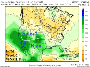
Discussion: Powerful Southwest U.S. storm track produces copious snow across mountain areas and heavy rain on the California Coast. The storm track produces wider Southern U.S. anomalous chill.
Week-3 Ahead Forecast valid January 9-15, 2024: Much of U.S. is stormy.
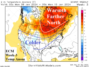
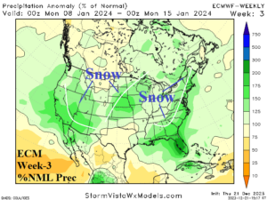
Discussion: The storm track remains potent and has support aloft to generate enough cold to cause some areas of snow. The Southern States are colder than indicated by ECM.
Week-4 Ahead Forecast valid January 16-22, 2024: Warm ECM persistence.
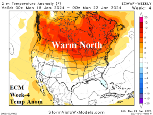
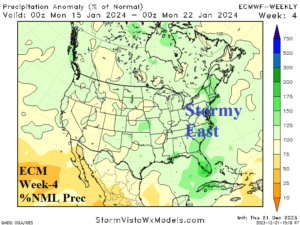
Discussion: ECM showing persistence…strong warmth and an East Coast storm track.