
Why Is Gulf of Mexico and Caribbean Sea Lacking TC’s So Far?
08/27/2025, 5:29 am EDT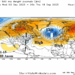
High Pressure in Subtropics Suppressing TC Development for Western North Atlantic Basin
09/03/2025, 5:01 am EDT
Climate Impact Company Early AG Market ALERT
Issued: Friday August 29, 2025
Highlight: -IOD/La Nina shift, U.S. chilly 6-10-day forecast, and wet Western Europe 15-day outlook while Black Sea region is very dry.
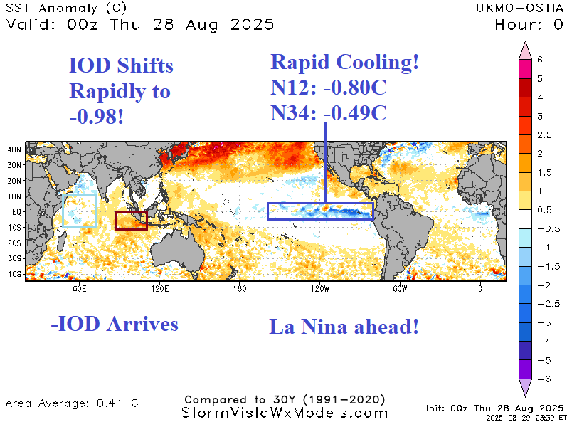
Fig. 1: The daily global tropics SSTA analysis.
Discussion: During the past week, the Nino SSTA regions have cooled dramatically (Fig. 1). The Nino34 SSTA is -0.49C today, very close to the -0.50C La Nina threshold. Off the northwest coast of South America, the Nino12C chilled rapidly to -0.80C. In the tropical Indian Ocean, the western areas have cooled while the southeast tropics have warmed dramatically signaling a moderate-to-strong negative Indian Ocean dipole (-IOD). The combination of -IOD and La Nina is likely for Q4/2025. The influence on climate is possibly dramatically wet from Southeast Asia to Indonesia and Australia and the environment for late season North Atlantic tropical cyclones should improve.
The sharp cool pattern centered on the Midwest U.S. peaking during the 6-10-day period (Fig. 2) is sufficiently chilly to drawn <32F risk into Southern Canada (Fig. 3). Downstream from the trough, an upper ridge is located over the northwest North Atlantic Ocean compensated for by another deep trough off Northwest Europe causing soaking rains through the next 2 weeks (Fig. 4). Farther east, an amplified ridge brings dry and very warm weather well into September for the Black Sea region (Fig. 5).


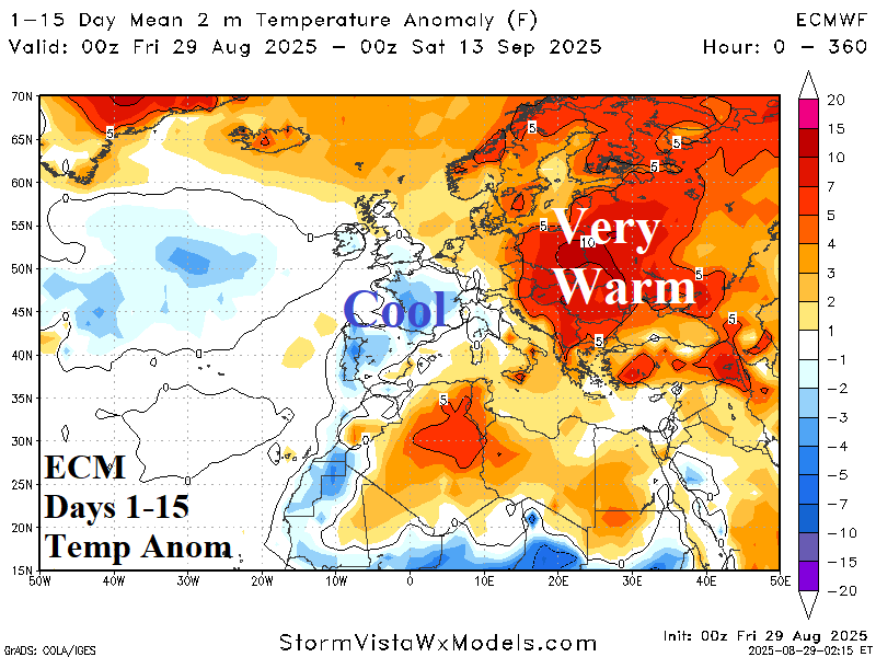
Fig. 2-5: The U.S. CMC ENS 6-10-day temperature anomaly forecast, GFS ENS risk of <32F outlook for days 6-10, and ECM 15-day rainfall and temperature anomaly forecast for Europe.