-IOD/La Nina Inspired Wet Climate Ahead for Australia
09/03/2025, 6:02 am EDT
South America and Australia Spring 2025 Outlook Review
09/07/2025, 12:04 pm EDT
Climate Impact Company Early AG Market ALERT
Issued: Thursday September 4, 2025
Highlight: Upper ocean heat foreshadows IOD/ENSO regime, Ohio Valley dryness is ongoing, and showery eastern Black Sea region.

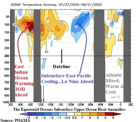
Fig. 1: The equatorial oceans subsurface upper ocean temperature anomalies.
Discussion: The subsurface equatorial upper ocean heat profile foreshadows phase change of various modes of climate variability. In the Indian Ocean, the eastern portion of the equatorial region has warmed significantly (Fig. 1). Implied is evolution of a potentially strong negative phase of the Indian Ocean dipole (-IOD). The daily IOD index is robust -1.04. The -IOD regime has arrived. -IOD biases Southeast Asia, Indonesia, and Australia much wetter than normal for SEP/OCT/NOV 2025. In the equatorial Pacific, the eastern portion has cooled significantly. Implied is an approaching La Nina episode. The daily Nino34 SSTA is close to the -0.5C La Nina threshold while the Nino12 SSTA, off the northwest coast of South America, is near -1.0C cooling by 1.25C over the last 30 days. The southern oscillation index (SOI) is increasingly positive with the 30-day SOI very close to the +0.5 La Nina threshold. A weak-to-moderate La Nina is ahead. The La Nina will enhance the -IOD wet anomalies previously mentioned, potentially provide some wet relief for the Brazil drought, cause West U.S. drought to shift eastward across the southern states, and dry out the East Africa tropics.
The eastern U.S. Corn Belt is drying out. The latest 15-day percent normal rainfall forecast stays very dry in this region. The wettest possibility is depicted by the ECM MAXRES which turns the Upper Midwest wet but leaves the Ohio Valley (and Southeast U.S.) dry to very dry (Fig. 2). The Midwest U.S. temperature regime is unusually cool through the weekend reversing to warmer than normal mid-September (Fig. 3).


Fig. 2-3: The ECM MAXRES 15-day percent normal rainfall forecast and the Midwest U.S. population weight 15-day daily average temperature outlook.
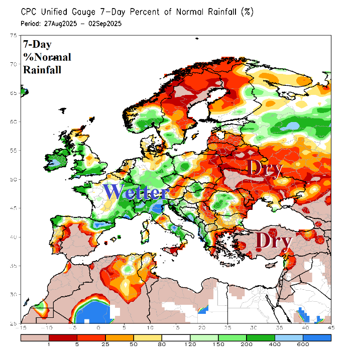
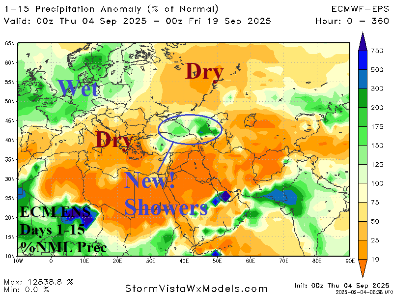
Wet weather has recently regenerated across parts of West and South-central Europe while torrid dryness persists in Spain, Turkey, Black Sea region, and Southwest Russia to Northern Europe (Fig. 4). Warmer than normal temperatures accompany the dryness, especially Poland where the past week has averaged 5C warmer than normal. The 15-day outlook according to ECM ENS is consistent indicating an upper trough maintains a showery regime for Western Europe although Spain stays dry while Southeast Europe to Western Russia remains drier and much warmer than normal (Fig. 5). An upper-level low-pressure system emerges and causes showery weather in the eastern Black Sea region.


Fig. 4-5: The 7-day percent of normal rainfall observations across Europe and the ECM ENS 15-day percent normal rainfall forecast for Europe/Western Russia.
