Europe Summer 2024 CDD’s…Staying Very Warm East
08/13/2024, 8:42 pm EDTDramatic Uptick in Tropical Activity Late August into Mid-September
08/14/2024, 11:47 am EDTHighlight: Heavy rainfall event slowly departing Australia East Coast.
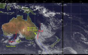
Fig. 1: Satellite view of a rainstorm on the Australia East Coast.
Discussion: Extreme rain has been produced by an unusual weather system on the East Coast of Australia during the past 1-2 days. An elongated cold front stretching northward from a polar vortex south of New Zealand joined forces with an inverted subtropical low-pressure trough off the Queensland Coast to produce an excessive rainfall event affecting Coastal Queensland and Coastal New South Wales. Local radar indicates the heaviest rains are shifting slowly offshore. Rainfall amount in the 4 in. range from MacKay to Byron Bay has caused flooding. Up to a total of 10 in. of rain has been reported in elevated areas near the NSW/Queensland border. The next storm located off the Southwest Coast of Australia races eastward today collecting some of the moisture from Australia East Coast storm to soak South Australia, Victoria, and New South Wales in the 24-48-hour period. A much warmer and drier period will follow.