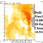
Sudden Warming of the Nino12 SSTA Region Affects South America Rainfall Pattern
02/13/2025, 5:19 am EST
Finally, Some East Europe/Southwest Russia Snow Cover and Following Cold
02/18/2025, 8:19 am EST
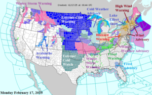
Fig. 1: NOAA/NWS weather watch, warning, and advisory areas.
Discussion: High impact weather affects most of the U.S. this week due to a February “polar vortex” episode. Currently, Extreme Cold Warnings are in effect for the North-central U.S. as temperatures have plummeted well below zero (Fig. 1). A veil of fresh snow ahead of the arctic air across the central Great Plains where Winter Storm Warnings are issued will allow the southward flowing arctic air to maintain intensity. Excessive rainfall over the weekend maintains flooding across much of Kentucky this morning with sharp temperature drops on the way. An ongoing high wind event is affecting the Northeast Corridor. High Wind Warnings are in effect for Pennsylvania/New York, and New England. A Blizzard Warning is in effect along the PA/WC state line with Lake Effect Snow Warning’s posted in Western New York. Avalanche Warnings are posted for Utah and Colorado Mountain areas ahead of another winter storm moving into the Northwest U.S.
NOAA/WPC synoptic map projections identify tomorrow morning’s heavy snow across the western and central Great Plains with freezing rain/icing in Oklahoma (Fig. 2). By Wednesday morning, the zero line surges south across fresh snow cover into northwest Texas while the freezing line is just northwest of Houston (Fig. 3). By Wednesday morning, a Mid-Atlantic snowstorm is developing with heavy rain in the Southeast. Thursday morning brings the full thrust of cold air into Texas with Houston near 28 (could be colder) and the freezing line into far southern Texas with zero near the TX/OK State Line northeastward to St. Louis and Chicago (Fig. 4). Atlanta drops to the mid 20’s Thursday morning. On Thursday snow is heading for southern New England. By Friday morning, the cold air mass is across the entire eastern half of the U.S. with another high wind event affecting the Northeast States (Fig. 5).
The NBM (model) is used to project this week’s snowfall. The TUE/WED forecast yields 4-12 inches of snow from Kansas to Virginia with high spots of 10-12 inches on the Kansas/Missouri State Line (Fig. 6). Moderate snow is likely for the northern Mid-Atlantic/southern New England coastal areas late this week (Fig. 7).
The U.S. population weight HDD forecast into early March projects warming (Fig. 8).
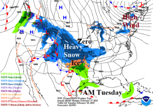
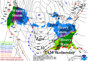
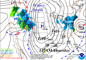
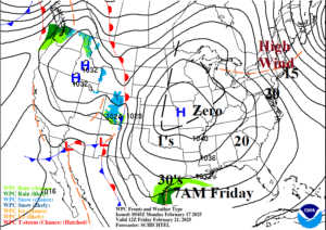
Fig. 2-5: NOAA/WPC synoptic frontal projections each morning of this week with annotated hazardous weather highlights.
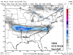
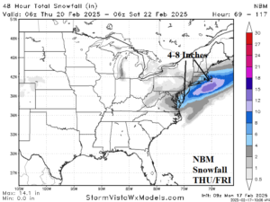
Fig. 6-7: NBM TUE/WED and THU/FRI snowfall forecasts.
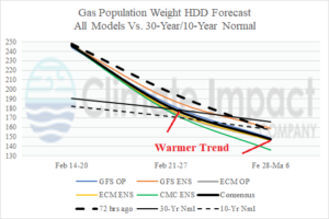
Fig. 8: U.S. gas population weight HDD forecast utilizing all models, their consensus, and comparing with the forecast from 72 hours ago plus the 30-year/10-year normal.