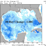
Dramatic Cooling of the Gulf of Mexico
06/24/2024, 9:14 am EDT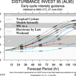
Tropical Cyclone Models Develop 95L to a Hurricane
06/27/2024, 9:55 am EDT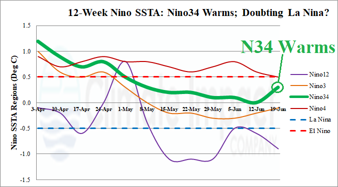
Discussion: The Nino34 SSTA located in the east-central equatorial Pacific Ocean warmed to +0.3C last week (Fig. 1). The 30-day southern oscillation index (SOI) average is an El Nino-like -0.66 and projected to finish June at the -0.50 El Nino threshold (Fig. 2). Upper ocean heat in the equatorial Pacific was at a cool peak, supportive of La Nina development 2-3 months ago. Since that time the cool anomaly to support La Nina has lost half of its intensity (Fig. 3). The expected trend of the ENSO System toward and into La Nina has clearly stalled.
The Australia Bureau of Meteorology has stated: “The global sea surface temperatures (SSTs) have been the warmest on record for each month between April 2023 and May 2024. These global patterns of warmth differ to historical global patterns of sea surface temperatures associated with ENSO and IOD; therefore, future predictions based on historical SSTs during past ENSO or IOD events may not be reliable.”
The daily global SSTA analysis reveals a robust warm signature (+0.55C) unchanged from 30 days ago and the same as this time last year. The record warm global SSTA continues (Fig. 4). La Nina development during the record warm global SSTA regime is apparently difficult and expectations of La Nina in 2024 are lowering.
The projected Nino34 SSTA for July 2024 based on trends is right at zero as forecast by ECMWF (Fig. 5). Using the ECMWF forecast for November 2024 yields -0.4C for Nino34 which remains within the neutral ENSO threshold (Fig. 6). Based on trends, the ECMWF lack of La Nina projection for 2024 is the most correct projection of all dynamic models.
The lack of a La Nina for the North Atlantic tropical cyclone season coupled with some cooling in the upper ocean heat anomalies across the tropical Atlantic Ocean imply seasonal hurricane activity for 2024 may be closer to the lower range of the various forecasts issued during spring. The Climate Impact Company projection of 21 storms, 10 hurricanes, and 5 intense hurricanes is a buoyant outlook but is the least active of most available outlooks. Seasonal tropical cyclone outlooks by Colorado State University, U.K./Tropical Storm Risk, and Climate Impact Company are updated in early July.
Climate patterns are likely to be increasingly influenced by mid-latitude marine heat waves, at least on a regional basis, versus the influence of a weak ENSO pattern and neutral Indian ocean dipole (IOD).
Fig. 1: The 12-week Nino region SSTA tracker indicates the key ENSO phase identifier, Nino34 SSTA, has warmed during the past week.
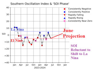
Fig. 2: The southern oscillation index continues to resist a shift toward La Nina.
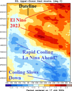
Fig. 3: The upper ocean heat east of the Dateline in the equatorial Pacific Ocean cooled to support La Nina ahead during MAR/APR 2024 but has weakened since that time.
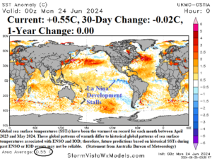
Fig. 4: The daily global SSTA analysis reveals a robust warm +0.55C average which is unchanged from one year ago. Global SSTA has been record warm each month since April 2023. The anomalous warmth is defeating La Nina formation.
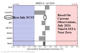
Fig. 5: A collection of dynamic models projecting ENSO phase using Nino34 SSTA forecasts for July. ECMWF is the most correct short-term forecast.
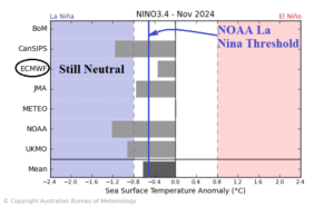
Fig. 6: A collection of dynamic models projecting ENSO phase for November 2024 using Nino34 SSTA indicates mixed results. The favored ECMWF forecast remains in neutral phase.