New NOAA Long-lead Climate Forecasts Implicate Southeast U.S. for Tropical Cyclone Risk
07/17/2025, 9:18 am EDT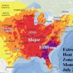
Extreme Heat Southeast U.S.
07/24/2025, 7:21 am EDT

Climate Impact Company Weekly ENSO Climate Diagnostics
Issued: Monday July 21, 2025
Highlight: Cooling Nino34 SSTA develops.
Discussion: The Nino SSTA regions edged slightly cooler during the past week (Fig. 1). Currently, the Nino34 SSTA has shifted cooler to -0.2C. The La Nina threshold is -0.5C. The southern oscillation index (SOI) is projected moderately positive for July and within the La Nina threshold (Fig. 2). The +SOI regime implied above normal strength trade winds up-welling cooler water to the surface. +SOI is forecast to continue during the remainder of July. The steady +SOI will encourage trade winds to continue. The upper ocean temperature anomaly structure in the eastern equatorial Pacific indicates a new moderately deep cool layer (Fig. 3). The warm layer just beneath the surface is beginning to weaken. The long-term ENSO outlook for later in 2025 remains in the neutral phase. However, as observed all of 2025, some models are indicating La Nina development, and a slight cooler trend has developed supportive of the La Nina outlier forecasts.

Fig. 1: The 12-week monitor of the Nino SSTA regions.
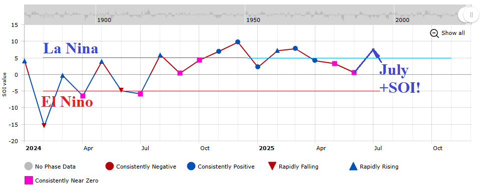
Fig. 2: The monthly southern oscillation index observations since early 2024 including the projected JUL-25 value.
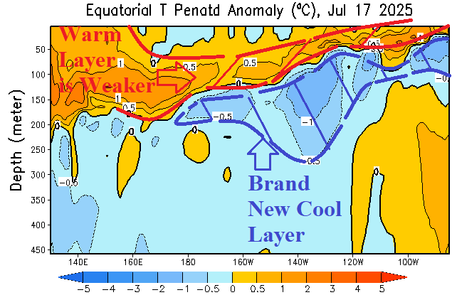
Fig. 3: The subsurface equatorial Pacific Ocean upper ocean heat anomalies.