Fast Trade Winds Preventing Very Active North Atlantic TC Regime
08/18/2024, 9:39 am EDTIndian Ocean Dipole Shifts Negative, Albeit Weak
08/27/2024, 2:34 pm EDT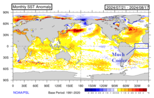
Fig. 1: Global SSTA analysis for the past 30 days reveals a much cooler equatorial Atlantic while the record warm pattern remains to the north. The cooler (very) low latitude ocean surface has caused the ITCZ to shift farther north.
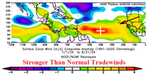
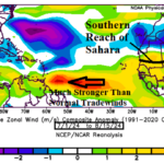
Fig. 2: Trade winds are unusually strong across the North Atlantic tropics so far this summer season. Strong trade winds lower the risk of developing tropical waves.

Fig. 3: This morning’s North Atlantic weather satellite view identifies the North Atlantic tropics across the Caribbean Sea eastward nearly cloudless.
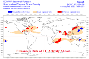
Fig. 4: ECMWF projection of greatest risk of tropical cyclone activity ahead beginning in September. Note the high risk in the North Atlantic is across the western basin.
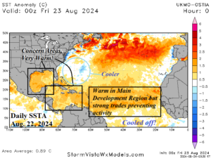
Fig. 5: Daily North Atlantic SSTA analysis reveals the most favorable zones for tropical cyclone development is in the Caribbean Sea and Gulf of Mexico located west of the strong trade winds. Note the cooler waters off the East Coast.
Discussion: The North Atlantic tropics are unusually quiet for late August, especially given the very active hurricane year previously forecast. The likely primary cause of the quiet pattern is related to the “strongest warm to cool transition of equatorial Atlantic SSTA” since 1982 according to recent research published by the Cooperative Institute for Marine and Atmospheric Studies. The cooling of the equatorial Atlantic (Fig. 1) has forced the intra-tropical convergence zone (ITCZ) to shift farther north than usual where the SSTA pattern remains very warm. However, in this region, the summertime trade winds are much stronger than normal (Fig. 2) preventing ITCZ organization and lowering the risk of developing tropical waves. Consequently, the North Atlantic basin tropical latitudes are remarkably all-clear this morning (Fig. 3). Going forward, the conditions preventing tropical cyclone development in the lower latitudes may improve slightly. However, optimal conditions for tropical cyclone development are likely most favorable over the western North Atlantic basin according to ECMWF (Fig. 4). Although seasonal activity may be lower than previously forecast, the dangerous character of the forecast remains, as proximity of tropical systems to the U.S. mainland is much above normal risk. The daily SSTA analysis across the North Atlantic basin reveals strong warm anomalies in the main development region (MDR) for hurricanes (Fig. 5). However, strong trade winds are lowering the risk of development. West of the trade winds, the Caribbean Sea and particularly the Gulf of Mexico are much warmer than normal and favorable for future development. Recently, waters off the East Coast have cooled, in part due to Ernesto. However, rewarming is expected warranting the claim by ECMWF of significant East Coast risk of tropical cyclone encounters for SEP/OCT.