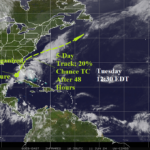
New Potential Tropical System in The East Gulf
06/11/2024, 2:57 pm EDT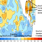
The Tall Waters of the Gulf of Mexico
06/13/2024, 2:34 pm EDT
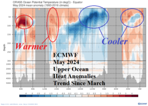
Fig. 1: Upper ocean heat temperature anomalies in the equatorial region of each ocean basin and the annotated 2-month trend.
Discussion: Colorado State University issued their June 11th North Atlantic basin seasonal tropical cyclone forecast revealing no changes from the previous 23 storms/11 hurricanes/5 intense hurricanes/210 ACE index. The outlook remains scary, especially the number of hurricanes and buoyant ACE index. 10 or more hurricanes have occurred during 5 seasons since 2000 and in just 9 seasons since 1950. The ACE index forecast is 6th highest since 1950. The Climate Impact Company outlook is one of the most conservative outlooks released to markets with 21 storms/10 hurricanes/5 major hurricanes/180 ACE index. The more conservative numbers have some support as despite the cooling equatorial East Pacific subsurface, a La Nina trend is not developing at the ocean surface as ENSO has settled into neutral phase. Australia Bureau of Meteorology indicates a <50% chance of La Nina until very late in 2024. Additionally, the upper ocean heat anomalies in the North Atlantic tropical region remain impressive but somewhat cooler than 2 months ago. Consequently, the ideal pattern to support hurricane development of a low wind shear regime in the upper atmosphere caused by La Nina coupled with very warm upper ocean heat is looking less impressive.