Current Heavy Rain Episode Shifts South, More Rain Mostly Northern Half of Europe Late September
09/16/2024, 4:32 am EDTU.S. Gas Population Weight HDD Forecast Reveals Warm Winter 2024-25
09/18/2024, 2:50 pm EDTExecutive summary: A relentless review of the current ENSO status and trend plus dynamic model and analog forecasts reveals a surprise in Climate Impact Company (CIC) September 2024 ENSO Report: A stronger La Nina ahead! CIC reviewed all ENSO analogs based on multi-variate ENSO index (MEI) and the conventional Nino34 SSTA index. Indicated is a moderate to strong La Nina ahead for Q4/2024 (Fig. 1). The result is a much stronger La Nina than previously indicated. To validate the analog, a review of all leading dynamic models followed. Of 6 dynamic ENSO models offered by Australia, Canada, ECMWF, Japan, NOAA, and U.K. only the Australia Bureau of Meteorology forecast indicated weak La Nina with the remaining outlooks close to the CIC analogs. Consequently, climate forecasts valid for Q4/2024 and Q1/2025 are more heavily biased toward La Nina climate. As a review, a recently updated global La Nina precipitation climatology from the International Research Institute (IRI) for Climate and Society at Columbia University is provided (Fig. 2). In the U.S., La Nina supports drought development across the Southern U.S. with wet climate in the Ohio Valley (which would end the current drought) and Washington. Globally, Central America and northern South America are wet. The Panama Canal water levels recover. South of the northern South America rains, the remainder of Brazil to Argentina slip into drought. Australia to Southeast Asia is wet. The Middle East and East China are dry. La Nina certainly affects thermal climate. However, nowadays, given the anomalous warm ocean (Fig. 3), probability and analog forecasts are almost always warmer than normal as demonstrated by the OCT/NOV/DEC 2024 temperature probability forecast by IRI (Fig. 4). The MEI has already shifted to a weak La Nina climate. Support for an uptick in North Atlantic basin tropical cyclone activity for late season is developing. Aside from any tropical cyclone activity, the Southern U.S. should trend drier with expanding drought. A wetter northern South America climate related to La Nina is likely to develop. Australia is likely to shift wetter heading toward their summer.
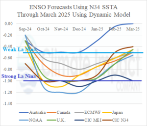
Fig. 1: The SEP-24 to MAR-25 Nino34 SSTA forecasts by leading dynamic models and Climate Impact Company analog forecasts which includes an MEI analog.
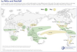
Fig. 2: The La Nina global precipitation anomalies recently updated by the International Research Institute for Climate and Society at Columbia University.
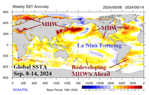
Fig. 3: The ongoing anomalous warmth of the global oceans as observed during the week of Sep. 8-14, 2024. The AUG-24 global SSTA was 2nd warmest on record.
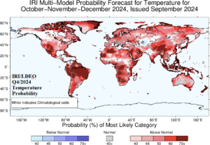
Fig. 4: The global IRI temperature probability forecast for Q4/2024.
Discussion: A shift from the 2023-24 El Nino toward La Nina has been very slow. During August, the potential vertical velocity in the global tropics was neutral almost everywhere indicating weak to almost no ENSO influence (Fig. 5). However, a period of positive southern oscillation index (+SOI) developed after mid-August and lasted 3 weeks (Fig. 6) which propelled trade winds to initiate up-welling of cool subsurface waters in the equatorial East Pacific (Fig. 7) leading to a cooler daily Nino34 SSTA index already approaching the La Nina threshold as of this week (Fig. 8). The notably cooler subsurface in the central/eastern equatorial Pacific (Fig. 9) foreshadows potential for a stronger La Nina ahead. Consequently, CIC analog forecasts of the Nino34 and MEI are adjusted more confidently to La Nina and due to the stronger signature, the risk of a lengthy La Nina for 2025 increases (Fig. 10-11).
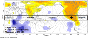
Fig. 5: The potential vertical velocity identifying tropical convection/subsidence areas in the deep tropics was unusually near neutral in August 2024.
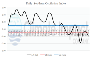
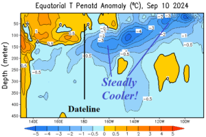
Fig. 6-7: The daily southern oscillation index flipped positive later in August causing increased trade winds to up-well the cooling waters of the eastern equatorial Pacific Ocean.
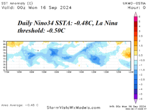
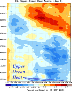
Fig. 8-9: The daily Nino34 SSTA index has cooled to near the La Nina threshold and recently, upper ocean heat has cooled across the equatorial East Pacific to the Dateline.
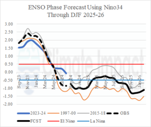
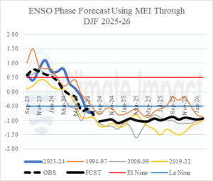
Fig. 10-11: The Climate Impact Company Nino34 and MEI analog forecast is more assertive with a La Nina ahead possibly lingering through most of 2025.