Southeast Europe to Southwest Russia Heat Alert!
07/05/2024, 5:07 am EDTJune 2024 Was 2nd Hottest on Record in U.S.
07/09/2024, 7:29 pm EDT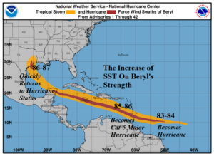
Fig. 1: The wind profile track for Beryl and locations of intensity increases as related to warming SST.
Discussion: Beryl’s response to the anomalous warm SST during the early July trek was notable (Fig. 1). First, Beryl became a hurricane once SST warmed to 84F in the central North Atlantic tropics. The earliest hurricane on record for this location was born as SST was much above the usual (for July 1) 81-82F SST for this region. Once into the Eastern Caribbean Sea, the SST warmed to 86F. This value was about 3F warmer than normal. SST of 86F is sufficient to power a major hurricane and Beryl intensified to a 934 MB/165 mph category-5 major hurricane. The upper shear eased (slowly) the intensity of Beryl moving through the western half of the Caribbean Sea. The passage across the Yucatan plus cooler SST off the northwest coast of the peninsula severely damaged Beryl. However, crossing 86-87F water off the Texas Coast enabled Beryl to reach hurricane status before moving inland. The hurricane was intensifying rapidly at landfall causing stronger than expected weather across the Houston area. If Beryl was offshore for another couple hours, a category-2 hurricane would have easily emerged.
Currently, the remains of Beryl are tracking through Arkansas and a northeast trek while continuing to weaken is expected over the next couple days as Beryl travels to Quebec (Fig. 2). Heavy rain (3-5 in.) will strike Illinois/Indiana today and New York on Wednesday. Elsewhere, all clear for now. The upper shear pattern is very light in the central and eastern tropical North Atlantic.

Fig. 2: Morning weather satellite view of the North Atlantic tropics and subtropics.