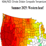
Forecast Confidence for U.S. Summer 2025 Outlooks
04/11/2025, 8:53 am EDT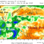
Heavy Rain Ahead Western Europe, Black Sea Turns Warmer
04/15/2025, 4:56 am EDT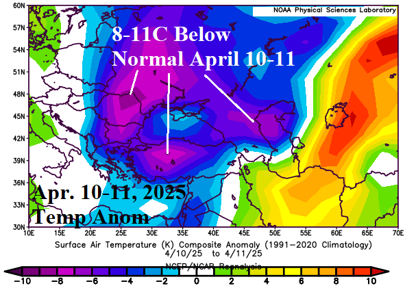

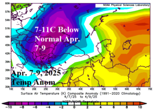
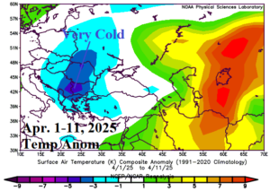
Fig. 1-3: Temperature anomalies across Eastern Europe and the Black Sea region for April 10-11, April 7-9, and April 1-11, 2025.
Discussion: A late season cold wave has produced significant crop damage to the Eastern Europe/Black Sea/Turkey/Southwest Russia region. The farthest east cold spike was April 10-11 causing the worst freeze since 2014 in Turkey (Fig. 1). The peak cold during April 7-9 was across Romania and Ukraine (Fig. 2). Coldest mornings during the freeze events were in the -10’sC! So far, the month of April cold anomaly peak is fixed over Southeast Europe (Fig. 3). The upper air pattern during Q1/2025 featured high pressure centered over Northwest Eurasia. During the past 30 days, the high-pressure area split with one center over U.K. and a second over Southern Russia while in-between, a small but potent polar vortex formed on the Northwest Russia Coast (Fig. 4). During early April, the polar vortex elongated into Southeast Europe in-between the two strong high-pressure areas to cause the cold (Fig. 5). The outlook projects a warm-up with the next issue a gathering rainstorm over the next 2 weeks across Southwest to South Europe featuring excessive amount (Fig. 6). All models are agreeable on the wet regime through 10 days with GFS maintain wet weather through the 11-15-day period. The bulk of the heavy rain is to the west of the Black Sea region. Climate Impact Company will issue the summer 2025 outlook later today. Right now, CFS V2 projects wet risk across the Black Sea region in May (Fig. 7).
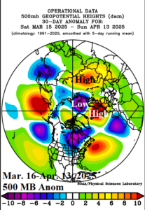
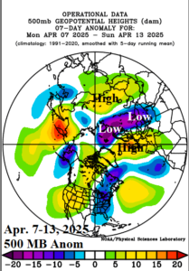
Fig. 4-5: The 30-day and 7-day upper air pattern across the northern hemisphere identifying the source of the Southeast Europe cold wave.
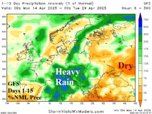
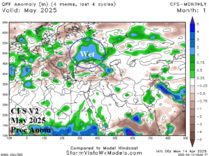
Fig. 6-7: The GFS 15-day percent of normal rainfall forecast across Europe/Western Russia and the May 2025 CFS V2 precipitation anomaly forecast.