Prohibitive Wet Weather Ahead for Central U.S.
04/23/2024, 7:58 am EDTNew Transitional U.S. Thermal Pattern Lowers Forecast Skill
04/28/2024, 11:59 am EDT
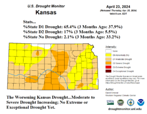
Fig. 1: Latest NOAA/USDA drought analysis across Kansas.
Discussion: Yesterday’s NOAA/USDA drought analysis across Kansas reveals worsening conditions. Although harsh extreme to exceptional drought is not present, almost all of Kansas (97.9%) is abnormally dry to severe drought (Fig. 1). Drought worsening is most apparent in the 3-month change which reveals an increase of 38% to 65% of D1 drought conditions and 5.5% to 17% of D2 (severe drought) conditions. Similar conditions are indicated across the northern third of Oklahoma. Drought conditions in Iowa are improving as 24% of the state is no longer in a drought condition whereas only 3% of Iowa was not in drought 3 months ago.
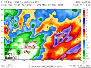
An upper trough “digs” into the Interior West U.S. through the next 5-7 days. The upper trough invites a surge of Gulf moisture northward into the Central U.S. causing many days of severe weather and heavy rain. The GFS indicates extreme rain is likely to strike Eastern Kansas and Western Missouri with potential for 10 inches over the next 7-10 days (Fig. 2). However, the west and particularly southwest part of Kansas receives minimal rainfall.

Fig. 2: The GFS 10-day rainfall forecast for the Central Great Plains region.
