12Z GFS Cold Bias Polar Region; Warm Bias Near U.S./Canada Border Past 30 Days
04/22/2024, 1:37 pm EDTKansas Drought Worsening; Incoming Rains Miss Southwestern Kansas
04/26/2024, 3:44 am EDT 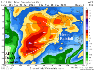
Fig. 1: AIFS 15-day rainfall forecast across the U.S. AG Belt.
Discussion: The western half of the North Pacific while the eastern half is temperate and unchanging. The negative (cool) phase of the Pacific decadal oscillation (-PDO) leaves the door open to susceptibility of upper troughs into the West U.S. Downstream, the upper trough inspires a moist southerly flow into the Central U.S. through much of the next 2 weeks. As a result, heavy to excessive rainfall is indicated by all models including AIFS across the central and eastern Great Plains in the 15-day outlook (Fig. 1). The cool weather of this week reverses warm Central and East next week into the following week. The late season HDD forecast is above normal this week (Fig. 2). However, already warm forecasts for the next 2 weeks trend warmer with today’s forecast. CDD count remains below HDD values.
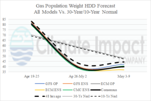
Fig. 2: The U.S. gas population weight HDD forecast utilizing all models, their consensus, and comparing with 48 hours ago and the 10-year/30-year normal.