
AI Graph Cast ECM ENS Becoming No. 1 Performing Model across North America in Medium-range
02/02/2025, 12:41 pm EST
Excessive Heat/Dryness Warning Argentina!
02/06/2025, 4:01 am EST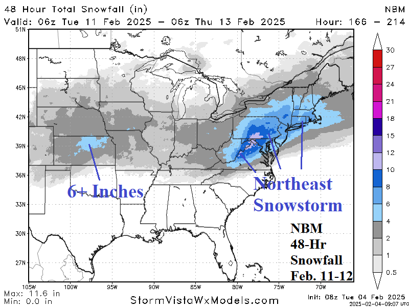
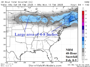
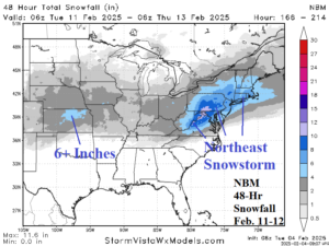
Fig. 1-2: NBM forecasts two significant snowfall events across the northern part of the East U.S. beginning this weekend and next week.
Discussion: Although extended range U.S. forecasts trend milder overnight, there is a caveat for the Midwest to Northeast U.S. Corridor. During next week’s cold, the North and East U.S. storm track turns snowy. Consequently, as the U.S. enters the extended range, snow on the ground could allow chilly air to linger, especially in the Northeast. Beginning this weekend, a snowfall event unfolds across the Upper Midwest shifting eastward and gaining strength in New England. A general 4-8-inch swath of snow is expected with this event with high spots near one foot in Maine according to the National Blend of Models (NBM) forecast (Fig. 1). The NBM (model) is the preferred model by NOAA generating precipitation forecasts. A second storm emerges next Tuesday in the Central U.S. shifting east and intensifying once reaching the Northeast U.S. Corridor on Wednesday. NBM indicates 6+ in. of snow in Kansas and a widespread 4-8-inch snowstorm in the Northeast U.S. with high spots of >12 in. just west of Washington, DC and Baltimore (Fig. 2). Freezing rain/ice accretion is a potential problem. Ice accretion of 0.1 to 0.25 in. is possible across west/central Pennsylvania for storm 1 and similar amount for west/central Virginia for the second event.