The Helene Rainfall Amount Analysis
10/02/2024, 10:00 am EDTMuch Needed Rainfall in Argentina and Brazil Ahead
10/07/2024, 4:54 am EDTHighlight: Tropical Storm Milton forms in the Southwest Gulf. The environment and forecast models indicate a major hurricane heading for Tampa.
Discussion: Before looking at the forecast, let’s review the environment where Milton will develop.
First, the satellite view reveals intense thunderstorm activity near the center of Milton with a second cluster of thunderstorms northeast of the center (Fig. 1). A low-pressure area with attendant convection has moved into the southeast Gulf of Mexico. Milton may absorb the southeast Gulf thunderstorm activity as the storm drifts eastward. The shear axis is strong just north of the Northern Gulf Coast.
Milton is forecast to track eastward. The Gulf of Mexico SST reveals still very warm readings mostly in the 85-86F range (Fig. 2). The ocean surface averages a buoyant 1.0C to 1.5C warmer than normal across the central and southern Gulf (Fig. 3).
Tropical cyclone models are agreeable on a due east-northeast drift over the next 5 days heading toward the Tampa, FL area (Fig. 4). The steering guidance, based on the strong westerly axis well to the north, is clearly an unusual eastward tracking storm. The tropical cyclone models indicate a likely major hurricane by later Monday and all the way to the Florida West Coast (Fig. 5).
The HWRF and HMON models indicate an extremely dangerous storm well into the category-4 major hurricane intensity with minimum pressure in the 923-924 MB range as the storm is offshore and approaching the central West Coast of Florida (Fig. 6-7).
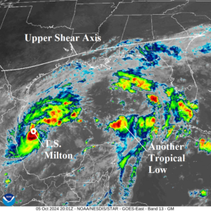
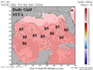
Fig. 1-2: Weather satellite view of the Gulf of Mexico and the daily SST analysis.
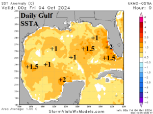
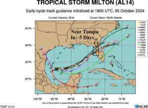
Fig. 3-4: The daily SSTA analysis and tropical cyclone models projection of tracks for Milton.
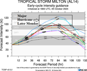
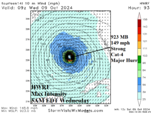
Fig. 5-6: Tropical cyclone models projection of intensity for Milton and HWRF maximum intensity forecast of Milton.
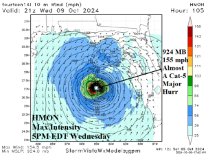
Fig. 7: The HMON maximum intensity forecast of Milton.