Some Wet Weather Ahead in the Black Sea Region
10/08/2024, 4:42 am EDTCatastrophic Category-5 Major Hurricane Milton Heading for Tampa Area Making Landfall Tonight
10/09/2024, 5:51 am EDTHighlight: Milton redeveloping a new eye, signs of an expanding hurricane. Northeast turning emerges. Major hurricane into Tampa area by 1AM Thurs.
NOAA: “Potential for one of the most destructive hurricanes on record for Western Florida”.
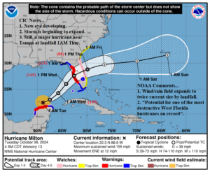
Fig. 1: The NOAA/NHC 5-day forecast track for Category-4 Major Milton.
Discussion: At 5AM EDT, Category-4 Major Hurricane Milton was located at 22.3N/88.9W or about 560 miles southwest of Tampa, FL. Milton is moving east-northeast at 12 mph with top wind near 155 mph. Central pressure is 924 MB. The NOAA/NHC 5-day forecast remains consistent, turning Milton northeastward tonight, and then into the Tampa Area as a strong category-3 major hurricane around 1AM Thursday. The forecast track is a little slower than yesterday’s forecast. Milton exits the East Coast of Florida as a hurricane late Thursday morning. Milton takes about 10 hours to travel across the Florida Peninsula. Once Milton is well east of Florida, the storm becomes extratropical.
Milton is undergoing the transition to a new eye. NOAA states that this is a sign that Milton is starting to expand. Thus far, Milton is an intense but relatively small hurricane. From now until landfall, NOAA states that the storm will double its size, and the hurricane wind and rain could extend beyond the cone of track uncertainty. Milton will turn northeast tonight moving in between a Northwest Gulf upper trough and a subtropical ridge to the east. Milton may gain some intensity today, back into category-5 major hurricane status moving over warm water with more distance from the Yucatan Peninsula. Once encountering southwest shear that guides Milton to Florida landfall the storm weakens slightly but remains a powerful major hurricane at landfall. NOAA states that Milton has potential to be one of the most destructive hurricanes to strike western Florida on record. Indeed!
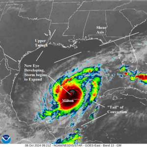
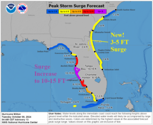
Fig. 2-3: Gulf of Mexico weather satellite view of “Milton” and NOAA/NHC storm surge outlook.
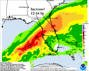
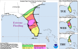
Fig. 4-5: The NOAA/NHC rainfall and flood risk forecast.


Fig. 6-7: The NOAA/NHC hurricane and tropical storm wind probability profile for Milton.
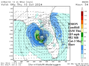
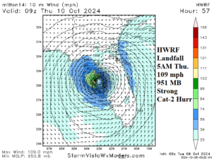
Fig. 8-9: HMON and HWRF landfall forecasts for Milton.