Eastern Europe Heatwave Ahead
08/21/2024, 5:22 am EDTExpanding Europe Heatwave
08/28/2024, 5:07 am EDT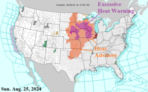
Fig. 1: The NOAA/NWS weather watch, warning, and advisory areas.
Discussion: Midwest EXCESSIVE HEAT EPISODE arrives as identified by advisories and warnings (Fig. 1). The peak heat is tomorrow and Tuesday (Fig. 2-3) when a Category-4 Excessive Heat Warning is in effect for northeast Kansas to southeast Minnesota (Monday) and western and northern Illinois (Tuesday). Within the Category-4 warning area the heat index reaches the 110-115F range. The strongest heat shifts into the Southeast U.S. mid-to-late week.
Of course, the excessive heat will trigger severe thunderstorms. On Monday, a large area of damaging wind is likely from northeast Nebraska to southern Minnesota (Fig. 4). Severe storms rumble across Michigan on Tuesday (Fig. 5). The hostile weather shifts into the Mid-Atlantic region as a heavy rain episode midweek.
The tropics are turning wetter (stronger ITCZ and wet trade winds) but no organized tropical event is seen through the next 10 days. Climate Impact Company will be re-issuing a seasonal outlook early this week cutting back on activity but the western North Atlantic still looks dangerous.
The U.S. medium-range forecast utilizes AIFS. Indicated is a cool change in the Central U.S. in the 6-10-day period shifting into the East in the 11-15-day period while the West turns hot (Fig. 6-7). The U.S. population weight CDD forecast trends cooler for the first third of September (Fig. 8).
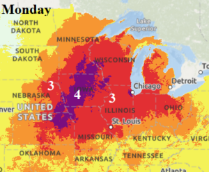
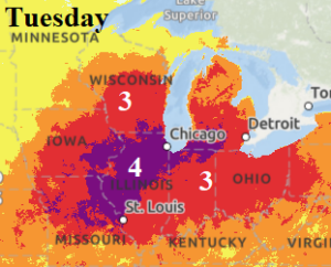
Fig. 2-3: NOAA excessive heat alert for the Midwest U.S. tomorrow and Tuesday.
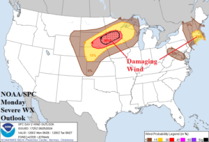
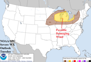
Fig. 4-5: NOAA/SPC severe weather outlook for tomorrow and Tuesday.
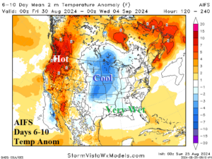
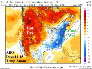
Fig. 6-7: The U.S. medium-range temperature anomaly forecast utilizing AIFS.
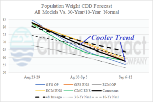
Fig. 8: U.S. population weight CDD forecast utilizing all models, their consensus, and comparing with 48 hours ago plus the 30-year/10-year normal.