New Marine Heat Wave Influencing South America Climate
01/15/2025, 11:26 am EST
La Nina Fairly Strong During DEC-24 Onset Weakens in January
01/20/2025, 2:08 pm EST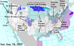
Fig. 1: NOAA/NWS weather watch, warning, and advisory areas
Discussion: As the weekend begins, a plethora of weather watch, warnings, and advisories are issued with many more ahead into early next week. Currently, an Extreme Cold Warning is issued for the northern Great Plains (Fig. 1). In the warning area, temperatures routinely collapse to -20F (or colder) with wind chills of -40F (or colder) by Monday morning. A Cold Weather Advisory is issued into the central Great Plains, certain to expand southward later today. Cold Weather Advisories are already in effect for Texas/Louisiana. Note the Extreme Cold Watch in-place for the central Gulf Coast, a precursor of what’s ahead for early next week. Extreme Cold Watch areas are issued for the Ohio Valley. To enhance the incoming cold, fresh snow cover is likely from West Virginia to Maine as Winter Storm Warnings are in-place and will expand for tomorrow.
By Sunday morning, the arctic air mass is through Texas although moderated across the southern Great Plains to the Gulf Coast due to the distant travel well south of snow cover (Fig. 2). The frigid arctic air is in the central Great Plains and northward. On the East Coast, a rainfall event which will gradually transition toward snow at night as the colder air mass arrives. By Monday morning, the cold air reaches the East Coast featuring 14-18F from Boston to Washington, DC (Fig. 3). The entire South U.S. chills to a moderated arctic air mass Monday morning good enough to push Atlanta to 16F, New Orleans to 27F, and Dallas to 20F. A new and even colder arctic air mass moves into the northwestern Great Plains early Monday. On Tuesday morning, a snowstorm develops in the northwest Gulf States (Fig. 4). Several inches of snow are likely in Houston to Baton Rouge. An added factor is the wind featuring entrainment of the cold air mass centered just to the north. There could be a streak of freezing rain/icing near the Gulf Coast but this winter event, for that region, is primarily sleet and snow except rain near the coast. The set-up propels extreme wind across Southern California. By the middle of next week, the East and South U.S. are extremely cold, including cold air enhancement over snow cover from the Gulf Coast to New England (Fig. 5). If skies clear over snow cover Wednesday morning, extremely cold teens could occur near Houston to Baton Rouge and eastward to Georgia. The Santa Ana wind continues Wednesday.
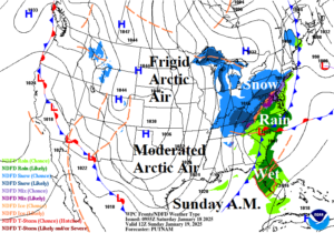
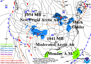
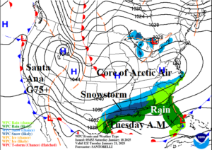
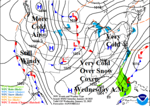
Fig. 2-5: NOAA/WPC synoptic maps for 4 mornings beginning with Sunday.
Looking past the arctic air, the U.S. thermal pattern moderates in late January/early February featuring near normal national heating demand by that time (Fig. 6). In February, the HDD forecast indicates below normal U.S. heating demand primarily due an expected milder pattern for the East while the West and Central U.S. will maintain cold exposure (Fig. 7).
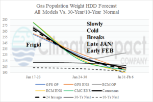
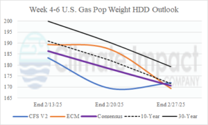
Fig. 6-7: The U.S. population weight HDD forecast utilizing all operational models, their consensus, and comparison with 24 hours ago and the 10-year/30-year normal plus the CFS V2/ECM week 3-5 outlook vs. yesterday and normal.

