ENSO-Neutral Persists, Weak La Nina Still Possible for Later 2024
07/13/2024, 5:08 am EDTSaharan Dust Arrives Suppressing TC Activity. Long-term effects?
07/16/2024, 12:03 pm EDTExecutive summary: One of the hottest early summer seasons on record has emerged so far in 2024. Accelerating the heat is the dry climate during this time in the southern Great Plains, Tennessee Valley and Interior Southeast U.S., and the Mid-Atlantic States. The combination of heat and dryness and in some cases long-term lack of precipitation indicates expansive drought is likely for mid-to-late summer. Again, anomalous heat is the accelerant as occasional rainfall, especially from inland traveling tropical cyclones is a constant late summer risk. Deep layer soil moisture deficits indicate the primary target for developing harsh drought are the east/south Great Plains, parts of the Missouri and Tennessee Valley(s), and the Mid-Atlantic region.
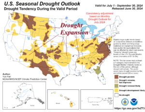
Fig. 1: The NOAA seasonal drought forecast valid through September 30th.
Discussion: As a review, NOAA issued a seasonal drought outlook earlier this month identifying expanding drought for much of the U.S. (Fig. 1). The primary driver of the expanding drought forecast is more so the anomalous heat as each location can receive rain at times. The Gulf States (near the coast) are the clear target for hurricanes during the AUG/SEP timeframe. Note that the East Coast trend is drier, and drought expands despite the buoyant hurricane forecasts.
The NOAA constructed analog system (CAS) soil moisture anomaly forecast for the end of August (Fig. 2) implicates Houston to New Orleans for land-falling tropical cyclones while the Atlantic Seaboard is dry implying hurricanes stay offshore. Residual moisture from northwest Gulf tropical systems works into the jet stream pattern to the north to deliver a thundery pattern to the Upper Midwest.
The NOAA CAS projection for September indicates the East is drier and maintains the wet signature centered on Louisiana and Minnesota (Fig. 3). The steady drying in the Mid-Atlantic also suggests an extremely hot mid-to-late summer.
An excellent predictor of drought development or, if drought is in-place, flash drought potential is the presence of deep layer (10-200 CM) soil moisture deficit. Moderate deficits are in place across East-Kansas and Missouri plus the Tennessee Valley (Fig. 4). If anomalous heat and generally drier than normal climate persists in these areas, rapid onset of drought is possible. Parts of Mississippi, and the Mid-Atlantic States are included.
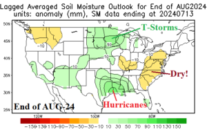
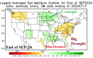
Fig. 2-3: NCEP CAS soil moisture anomaly forecasts for the end of August and end of September.
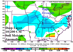
Fig. 4: Deep layer soil moisture deficits are caused by long-term climate patterns. Susceptibility to drought or flash drought increases across large soil moisture deficit regions.