June 2024 Was 2nd Hottest on Record in U.S.
07/09/2024, 7:29 pm EDTENSO-Neutral Persists, Weak La Nina Still Possible for Later 2024
07/13/2024, 5:08 am EDT| Tropical Storms | Hurricanes | Intense Hurricanes | ACE Index | |
| Climate Impact Company | 24 | 13 | 6 | 233 |
| Colorado State University | 25 | 12 | 6 | 230 |
| Tropical Storm Risk/U.K. | 26 | 13 | 6 | 240 |
| National Hurricane Center | 17-25 | 8-13 | 4-7 |
Table 1: All updated North Atlantic basin tropical cyclone season forecasts.
| Tropical Storms | Hurricanes | Intense Hurricanes | ACE Index | |
| 15-Year Normal | 17.7 | 7.9 | 3.5 | 132.5 |
| 30-Year Normal | 15.5 | 7.5 | 3.4 | 130.4 |
| 50-Year Normal | 13.0 | 6.6 | 2.7 | 107.0 |
Table 2: Various climatology identifying the increasing trend of seasonal tropical cyclone activity across the North Atlantic basin.
| Tropical Storms | Hurricanes | Intense Hurricanes | ACE Index | |
| 2024 So far | 3 | 1 | 1 | 36.1 |
| Normal for today | 1.7 | 0.3 | 0.1 | 4.3 |
Table 3: The North Atlantic basin tropical cyclone activity for 2024 so far.
Discussion: As stated by Colorado State University in their July 9 update, Category-5 Major Hurricane was a “harbinger” of what’s ahead during the 2024 North Atlantic hurricane season. The record warm sea surface temperatures across the Caribbean Sea and main development region (MDR) for hurricanes east of the Caribbean Sea provide an ideal environment for tropical cyclones to form and strengthen as shown by Beryl. The upper-level shear pattern is forecast lighter than normal due to an absence of an El Nino climate and potential for La Nina to develop. Ventilation in the upper atmosphere to allow tropical cyclones to flourish is above normal due to a shift into the westerly phase of the quasi-biennial oscillation (QBO). Colorado State University forecasts a 30-40% higher risk than normal of major hurricanes striking the U.S. Coast (after Beryl). The Climate Impact Company hurricane tracks forecast issued last spring indicted as many as 6 hurricane strikes to the U.S. this season which remains valid. The ACE index forecast of 230-240 is the second-most on record behind 245 in 2005. In 2005, the U.S. coastline encountered 6 hurricane strikes of which 4 were major hurricanes.
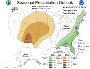
Fig. 1: The NOAA/CPC probabilistic precipitation forecast for AUG/SEP/OCT 2024 implicates the northeast Gulf, Florida, and Carolinas for highest risk of tropical cyclone coastal strikes.