Buoyant Mid-Troposphere Relative Humidity Promises Busy Season Ahead in North Atlantic Tropics
07/25/2024, 8:57 am EDTPossible Hotter Mid-August East; More Damaging Wind Midwest. Searing Mid-south heatwave underway!
07/30/2024, 6:06 am EDT
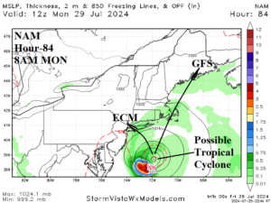
Fig. 1: The NAM SLP forecast indicates a possible tropical cyclone forming over 81-82F water east-southeast of New Jersey in 84 hours.
Discussion: A cold front moving through the Northeast U.S. followed by beautiful weather this weekend stalls in the Mid-Atlantic region. Offshore, along the stalled front, low pressure convenes over 81-82F water. The NAM, ECM, and GFS (models) each indicate a sort of a low pressure developing potentially gaining strength and becoming a minimal tropical system given the very warm water in that zone. NAM is strongest with a 999 MB low pressure area Monday morning at 8AM EDT (Fig. 1). If a system develops, ECM indicates a northwest drift toward NYC while GFS lifts this system north and northeastward across Cape Cod. Right now, a low-risk event, however forecast models began showing this potential issue yesterday and overnight the idea is maintained.
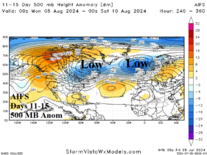
Meanwhile, the GFS brings a cool trough toward the northeast quadrant of the U.S. in the 11-15-day period. The forecast is in the face of very hot outlooks from the past few days. Additionally, GFS redevelops a Northwest Europe trough in 11-15 days disrupting the previous warmer/drier outlook for Western Europe at that time. GFS is a wildly varying forecast model. However, AIFS agrees with GFS on a different look for the 11-15-day period for both eastern North America and Western Europe (Fig. 2).

Fig. 2: The AIFS 500 MB Anomaly 11-15-day forecast indicates an amplified trough across Eastern Canada and just west of Europe.
