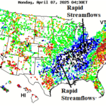
Rapid Stream Flows Ohio and Mississippi Valley
04/07/2025, 7:50 am EDT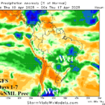
South America 2-Week Rainfall Forecast Trending Wetter!
04/10/2025, 4:10 am EDT
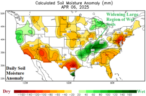
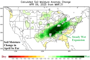
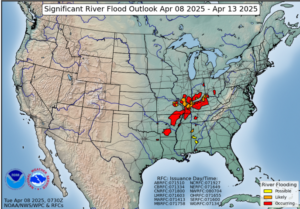
Fig. 1-3: Daily U.S. soil moisture anomalies and the April change so far plus areas of ongoing river flooding.
Discussion: Soaking wet soil moisture conditions are expanding rapidly in the Mid-south/Midwest U.S. due to the widespread 10-15-inch range of early April rainfall (Fig. 1-2). If significant rainfall returns to this region during the spring season, and the developing regional wet soil moisture profile strengthens, the influence on summertime climate favors increased cloudiness (and showers) suppressing heat risk. Meanwhile, ongoing severe flooding extends from Arkansas to Ohio in the NOAA 5-day outlook (Fig. 3). The high water will flow south through the Mississippi River through mid-month with water levels reaching moderate stage to near major flood stage based on current long-range forecasts. One exception is the Mississippi River at Baton Rouge forecast to shift firmly into the major flood stage beginning April 19th (Fig. 4). The historic major flooding episode of early April 2025 was caused by a vigorous upper trough across the West-central U.S. running into an amplified East U.S. ridge. In-between each upper-level feature, the southerly upper air flow (Fig. 5) transported deep tropical moisture into the U.S. fueled by unusually warm waters of the tropical East Pacific (Fig. 6).
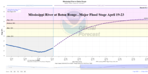
Fig. 4: Major flood stage along the Mississippi River at Baton Rouge is forecast beginning April 19.
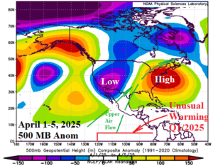

Fig. 5-6: The upper air pattern associated with the early April 2025 historic flooding episode in the East-central U.S. and the inclusion of deep tropical moisture from the warmer than normal ocean surface in the eastern tropical Pacific Ocean.