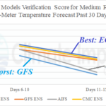
ECM Ensemble Best Medium-range Temperature Forecast Model for U.S. Past 30 Days; AIFS 4th Best
07/31/2024, 8:36 am EDT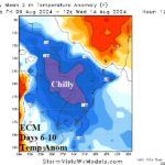
Turning Cooler South America in 6-10-Day Outlook
08/04/2024, 4:04 pm EDT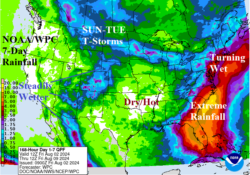
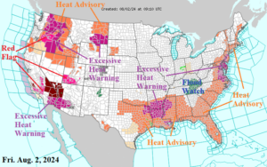
Fig. 1: NOAA/NWS weather watch, warning, and advisory areas.
Discussion: Excessive heat continues to dominate the U.S. weather pattern (Fig. 1). The super-hot and humid regime affects the Gulf of Mexico and Atlantic Seaboard States today. Excessive Heat Warnings are issued for the Mid-south States and Coastal Mid-Atlantic region. Returning to the forecast is a widening very hot risk across much of the Interior West. A total of 32 contiguous states has heat warnings or advisories.
The next issue is an evolving rainstorm in Florida and along the Atlantic Seaboard developing this weekend and lasting for much of next week. The culprit is Tropical Disturbance 97L, currently located over northwest Haiti, and given an 90% chance of tropical cyclone development after 48 hours (by NOAA/NHC). The preliminary forecast track is into the northeast Gulf of Mexico late weekend, across Northern Florida early next week, and slowly drifting north along the East Coast next week. The attendant rainfall is over 15 in. along the Carolina Coast according to NOAA/WPC (Fig. 2). A hurricane is possible in the far northeast Gulf and off the Southeast Coast. Awaiting actual development of 97L to a tropical cyclone is required before a confident track is rendered. Elsewhere, a slow developing Southwest U.S. Wet Monsoon is forecast into next week while a cooler air mass brings a cold front triggering thunderstorms early next week across the Canadian prairies into the northwest Great Plains. Dry and hot weather persists across the Mid-south U.S.
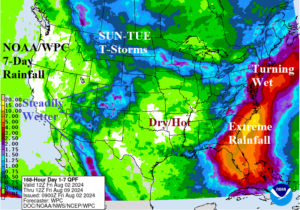
Fig. 2: The NOAA/WPC U.S. 7-day quantitative precipitation forecast.
The U.S. population weight CDD forecast reveals a collapse of the national heat after the current week (Aug. 2-8) to near normal through middle August although slightly warmer than yesterday’s forecast (Fig. 3).
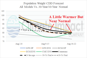
Fig. 3: U.S. population weight CDD forecast using all operational models and their consensus compared with 24 hours ago and the 30-year/10-year normal.