
La Nina Modoki Developing; El Nino to follow?
03/02/2025, 2:11 pm EST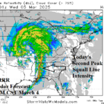
Major Severe Weather Outbreak South-central and East U.S. Next 2 Days
03/04/2025, 5:21 am EST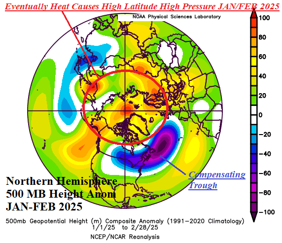
Discussion: Of course, the explanation is complex. But, in my view, a large contribution to the unexpected cold pattern occurring mid-to-late meteorological winter across the U.S. was caused by the poleward latent heat release (caused by seasonality) across the record warm northern hemisphere oceans last mid-to-late autumn (Fig. 1). Eventually the heat release produced high latitude high pressure blocking, most obvious during JAN/FEB 2025 (Fig. 2). The high latitude high pressure blocking pattern was compensated for in the middle latitudes in-part by an amplified low-pressure area across the northwest North Atlantic basin (Fig. 3). The upper trough “found” that region due to the cooling of the western North Atlantic basin while a vast marine heatwave continued across the eastern North Atlantic. Upstream from the MHW, a strong upper ridge dropped anchor on Europe further intensifying the upstream trough in the western North Atlantic. Stratospheric warming events occurred across Canada during mid-January and mid-February forcing polar vortex episodes in North America and causing the semi-permanent New England upper trough to expand westward. After the 4th warmest December on record in the U.S., the JAN/FEB climate was certainly unexpectedly chilly (Fig. 4).
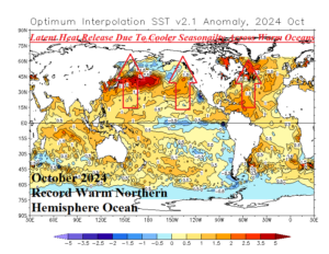

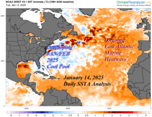

Fig. 1-4: Latent heat release due to seasonality across a record warm northern hemisphere ocean surface eventually caused high latitude high pressure blocking at 500 MB which was compensated for by a deep upper trough near New England attracted to that location by the cooling western North Atlantic Ocean. The result was a colder than expected JAN/FEB 2025 across the U.S.